There are a handful of places in the Highlands that stop you in your tracks the first time you spot them from the road, and for me the Fyrish Monument has always been one of them. Driving north on the A9, somewhere past Alness, you glance up at the hills and there it is – a row of stone arches and towers perched on the skyline, looking for all the world like a fragment of some ancient temple that has somehow washed up on a Scottish moor. I’d pointed it out to the girls from the car more times than I could count, always promising we’d climb up one day. This summer, on our way north to a caravan holiday at Grannies Hielan’ Hame in Embo, we finally did.

Janette and I had our three daughters with us – Ellie (16), Olivia (13) and Lauren (10) – which meant this was going to be a proper family expedition rather than a quick photography dash. As it turned out, it was one of the best afternoons of the whole trip: a walk with just enough challenge to feel earned, a monument with a genuinely fascinating (and slightly uncomfortable) story behind it, and views from the top that had all five of us standing in silence for a moment.
The story behind the stones
The Fyrish Monument was built in 1782 – and finished around 1785 – on the summit of Cnoc Fyrish, on the orders of Sir Hector Munro of Novar, the local laird. Munro was a career soldier who had made his name, and a considerable fortune, serving as a general in India. The monument is a deliberate replica of the Gate of Negapatam, a port near Madras (modern Chennai) that Munro had captured for the British in 1781. So what you’re looking at, atop a windswept Easter Ross hill, is a piece of 18th-century India rendered in local Highland stone.
That much is straightforward. The reason it was built is where the story gets more interesting, and more poignant. This was the era of the Highland Clearances, when landlords across the north were driving tenants off the land their families had worked for generations. Around Fyrish, people were struggling simply to survive. The monument was commissioned, at least in part, as a way of giving paid work to the local population – men who hauled stone nearly 1,500 feet up the hill for something in the region of a penny a day.

There’s a famous story attached to the building of it – that Sir Hector had stones rolled back down the hill at night so the work would take longer and the men would earn more. Whether that’s literal truth or Highland folklore that’s grown in the telling, nobody really knows; plenty of historians treat it as a nice legend rather than fact. Either way, it captures the two ways people have always read this monument. Was it an act of quiet generosity by a laird looking out for his people in hard times? Or was it a rich man’s vanity project, a personal trophy to his own military conquest, dressed up as charity? Standing beneath it, I found myself thinking it was probably a bit of both – and that the men who built it, penny by penny, are the ones whose effort really endures up there.
One detail I love: the monument was originally painted white, so it would have gleamed on the skyline far more starkly than the weathered grey we see today. And here’s something even many locals don’t know – the big monument isn’t alone. Sir Hector had two smaller, simpler monuments built on the neighbouring hills of Creag Ruadh and Meann Chnoc (the latter nicknamed “Little Fyrish”) at around the same time. They’re straight-sided, largely tree-enclosed and much less visited, and reaching all three makes a long loop for those with the legs for it. We stuck to the main event this time.
Our visit: the walk up
Getting there and parking
The walk starts from a dedicated forestry car park on the minor road towards Boath, signed off the B9176 (the Struie road). We parked up easily enough – it’s a decent size – though on a warm, blue-sky day like the one we had, it was filling steadily, so I’d not count on rolling up mid-afternoon in high summer and finding it empty. It’s free, which is always welcome, but there are no facilities here at all: no toilets, no cafe, no shop. Go prepared, especially with children.

At the edge of the car park a wooden gate and a cluster of information boards mark where the Jubilee Path heads off into the trees. A sign here tells you it’s 2 miles (3km) to the monument, asks you to keep dogs under close control, and – as ever in these parts – to take your litter home. Speaking of dogs: they’re very welcome, and we passed several happy ones on the way up, but there’s livestock and ground-nesting birds around, so close control genuinely matters here.

Through the forest
The first stretch is a real pleasure. The path winds up through tall, sun-dappled conifers, the light coming down in shafts between the trunks and the forest floor soft with needles and moss. It undulates – there’s a fair bit of gentle up and down rather than a relentless slog – and marker posts keep you right at the junctions. The girls set off ahead, and there’s something about a Highland pine wood on a bright day that puts everyone in good spirits.


Part way up, the path drops down a flight of steps to cross the Contullich Burn on a narrow wooden footbridge – a lovely, cool, green spot hemmed in by ferns and birch, with the water running below. Then it’s back up the other side. In places the going gets a little rougher and rootier, with mossy boulders lining the way, but nothing that troubled our ten-year-old. Sturdy shoes are a good idea though; there were muddy patches even after a dry spell.


The lochan – and a surprise visitor
One of the highlights of the climb, and a favourite with the girls, is a small lochan that sits just off the path as you near the open ground. On a still day its surface is a patchwork of pondweed and reflected sky, fringed with rushes and overhung by a lone pine. We stopped here for a while, and it was Lauren who spotted the star of the show: a newt, basking on a half-submerged log right at the water’s edge, perfectly still among the floating water-crowfoot. We must have watched it for ten minutes. It’s exactly the kind of small, unplanned moment that makes a walk stick in the memory long after the big views have blurred.


Onto the open hill
Beyond the lochan the trees begin to thin and the character of the walk changes completely. You climb out of the forest onto open moorland, the young pines giving way to heather and big sky, and the views start to open up behind you. This is where the effort of the climb starts paying dividends. Look back and the whole of the Cromarty Firth spreads out below, a broad blue sweep of water with patchwork fields, forestry and distant hills beyond. In late summer the hillside was flushed with purple heather, which made the whole scene sing.


The last section follows a stony path through the heather, and then – almost suddenly – the monument appears ahead on the crest of the hill. There’s a brilliant moment on the approach where you catch just the ragged tops of the flanking towers peeking over the rise before the whole structure reveals itself.

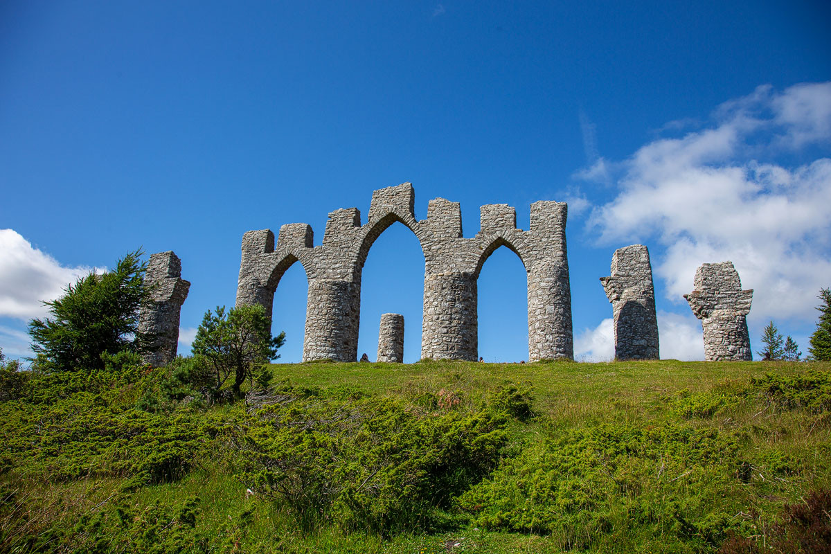
Up close, the Fyrish Monument is far more impressive than it looks from the road – and much bigger. Three central pointed arches are flanked by four great cylindrical towers, all built from local stone and topped with battlements, with a couple of shorter pillars standing slightly apart. There’s no roof and no enclosed interior; it was always meant to be an open, romantic “mock ruin”, and the years have only deepened the effect. The pillars aren’t quite in a neat line either – the outermost ones sit noticeably out of alignment with the main structure, which somehow adds to its strange, dreamlike quality.

It’s a wonderful place simply to potter about, walking between the towers and running your hand over stonework that local men set in place nearly two and a half centuries ago. The girls loved exploring in and around the arches, and there’s plenty of grassy space to sit and have a snack while you take it all in. We’d timed our arrival for early evening light, and had the place fairly quietly to ourselves bar a handful of other walkers.
I’d brought the drone up with me, and this is a spot that absolutely rewards an aerial view. From above, the monument reads almost like a stone crown set on the hilltop, with the Cromarty Firth glittering beyond and the patchwork of Easter Ross farmland rolling away to the coast. From higher still you get a real sense of just how isolated it is up here, marooned on a vast plateau of moorland with the hills of Sutherland and Ross ranged along the horizon – and, on a clear day, the blades of distant wind farms turning away to the west.


Of course, the views aren’t only for the drone. The panorama from ground level is every bit as good, and we spent a happy while just sitting and picking out landmarks – Invergordon and its port, the ribbon of the firth, the Black Isle away to the south. It’s the kind of view that makes the whole climb worthwhile in a single glance.


Before we headed back down, we all flopped onto the grass for a proper sit-down. There’s something about reaching a landmark you’ve pointed at from the car for years that’s deeply satisfying, and I think even the teenagers felt it. Then it was back down through the woods to the car, and on up the road to Embo.

Videos from the Fyrish Monument
Frequently asked questions
How long is the walk to the Fyrish Monument, and how hard is it?
It’s roughly 2 miles (3km) each way from the car park, so around 5 miles there and back, taking most people about 45 minutes to an hour to reach the top. It’s a steady, moderate climb on good forest and hill paths with a fair amount of gentle up and down, rather than a hard mountain slog. We managed it comfortably with a ten-year-old, though you’ll want a reasonable level of fitness and to allow plenty of time.
Is there a charge to visit, and do I need to book?
No. Both the car park and the monument are free, and there’s no booking required – you can simply turn up and walk. It’s open access all year round.
Where do I park for the Fyrish Monument?
There’s a dedicated free forestry car park on the minor road towards Boath, signposted off the B9176 Struie road. It’s a good size but can fill up on sunny weekends and in the school holidays, so arrive earlier in the day if you can.
Are there toilets or a cafe at Fyrish?
No – there are no facilities whatsoever at the car park or on the hill. The nearest shops, cafes and toilets are down in Alness and Evanton, so sort yourself out before you set off and bring water and snacks, especially with children.
Can I bring my dog?
Yes, dogs are very welcome and it’s a popular walk with dog owners. The signs ask you to keep dogs under close control, as there can be livestock and ground-nesting birds on the open hill, so it’s best to keep them close, particularly near the top.
Is the walk suitable for wheelchairs or pushchairs?
Unfortunately not. The path includes stone steps, a narrow footbridge, tree roots, loose stony sections and open moorland, so it isn’t suitable for wheelchairs or standard pushchairs. A sturdy back carrier is a better bet for very small children.
What are the three Fyrish monuments?
The famous arched structure is the largest of three monuments built by Sir Hector Munro. Two smaller, simpler ones sit on the neighbouring hills of Creag Ruadh and Meann Chnoc (“Little Fyrish”). They’re straight-sided, partly ruined and tree-enclosed, and much less visited – reaching all three makes a considerably longer walk for keen hillwalkers.
Key information
- Location: Cnoc Fyrish, near Evanton and Alness, Easter Ross, Highland
- Grid reference: NH 608 697 (monument); car park at NH 627 715
- Managed by: Novar Estate; Category B listed (Historic Environment Scotland)
- Entry: Free – open access all year
- Parking: Free dedicated forestry car park off the B9176 (minor road to Boath)
- Facilities: None on site – nearest in Alness and Evanton
- Accessibility: Not suitable for wheelchairs or pushchairs; steps, footbridge and rough ground
- Dogs: Welcome, under close control
- Walk: Approx. 2 miles (3km) each way, 45–60 minutes up
What else is nearby?
The Fyrish Monument sits in a lovely corner of Easter Ross with plenty more to explore close by:
- Black Rock Gorge: A short drive away near Evanton, this dramatic, deep and narrow wooded gorge – used as a filming location for one of the Harry Potter films – is crossed by two footbridges and makes a great, easy family walk.
- Storehouse of Foulis: On the shore of the Cromarty Firth at Foulis Ferry, a popular spot for a coffee, a bite to eat and some seal-spotting, with an interesting heritage exhibition attached.
- Dunrobin Castle: Further north towards Golspie, the fairytale seat of the Earls of Sutherland, with spectacular formal gardens and famous falconry displays.
- Invergordon murals: Down on the firth, this working port town is decorated with a celebrated trail of large outdoor murals telling the story of the area – an easy and free thing to do on a wet day.
- Tarbat Ness and the Seaboard villages: Out on the peninsula, a fine lighthouse, big skies and some of the best dolphin-watching on the east coast.
Final thoughts
The Fyrish Monument had been a “we really must climb that one day” landmark for our family for years, and I’m so glad we finally made the effort. It’s a walk that gives you a bit of everything – beautiful woodland, a burn and a footbridge, a lochan with its own resident newt, and then that thrilling moment when the trees fall away and the whole Cromarty Firth opens up beneath a genuinely extraordinary monument. Add in a story that sits right at the heart of Highland history, wrapped up in that uneasy mix of hardship, generosity and vanity, and you’ve got somewhere that stays with you.
If you’re travelling the A9 north of Inverness and you’ve got a couple of hours and a fine afternoon, do it. Take water, wear proper shoes, bring the kids – and if you’ve a drone, definitely bring that too. It’s one of the most rewarding short hill walks in this part of the Highlands, and we’ll be back to hunt down those two hidden monuments before long.

Leave a comment below