Look out to the Moray coast from almost anywhere between Elgin and Banff and one hill dominates the horizon: the distinctive round dome of the Bin of Cullen. For a hill that tops out at only 320 metres it has a disproportionate presence, rising cleanly out of the otherwise flat coastal plain and drawing the eye from every direction.
I’ve grown up with the Bin on my skyline. You can see it from my house near Buckie, from the harbour, from Strathlene Beach, and from pretty much every coastal viewpoint along this stretch of the Moray Firth. For all that, I’d only stood on its summit once, as a small boy, and could remember almost nothing about it. Thirty-six years later my wife Janette and I decided it was time to finally put that right – cameras in hand, kids in tow, on a bright, still autumn morning that turned out to be just about perfect. This is my guide to climbing what we all call the Bin Hill.

In this guide
- A landmark from every direction
- A brief history of the Bin of Cullen
- Getting there & parking
- Our walk up the Bin of Cullen
- The summit – trig point, cairn & picnic benches
- The view from the top
- Wildlife & nature on the Bin Hill
- A longer alternative: the Cullen House circular
- Best time to visit & what to wear
- FAQs
- Key information
- What else is nearby?
A landmark from every direction
Part of the Bin’s charm is that you can see it from almost anywhere on the Moray coast. Here are a few of the spots where it has sneaked into the background of photos I’ve taken for other guides on the site – it’s surprisingly hard to travel this stretch of Moray without the hill appearing somewhere in the frame.


A brief history of the Bin of Cullen
What’s in the name?
“Bin” is a Scots corruption of the Gaelic beinn, meaning hill or mountain – so the Bin of Cullen is, quite literally, Cullen’s hill. Although the town of Cullen gets the naming rights, the hill actually sits almost equidistant from Cullen, Findochty and Portknockie, and most Buckie locals just call it the Bin Hill.
Confusingly, it isn’t the only “Bin” in the northeast – there’s the Bin Hill near Huntly and Binn Hill at Kingston, both entirely separate hills. If you’re searching online for walking directions, make sure you’re looking at the right one.
Why is it so round?
The Bin owes its distinctive dome to a tough metamorphic rock called the Cullen Quartzite. Around 600 million years old, this pale, banded quartzite is far more resistant to erosion than the surrounding sedimentary rocks, so while the softer stone of the coastal plain has been ground down by ice and weather over countless millennia, the quartzite core has stood proud. It’s the same rock formation, tilted at a dramatic angle, that gives Bow Fiddle Rock at Portknockie its famous shape and creates the pale, angled cliffs you can see at Findlater Castle just along the coast.
A modest hill with a long list of labels
At 320 metres (1,049 feet) the Bin is nowhere near Munro territory – Munros are 914 metres and up – but hill baggers still make a beeline for it. It’s classified as a Marilyn (a hill with at least 150 metres of topographic prominence), as well as a HuMP, a Tump and a Yeaman. Four classifications for the price of one summit, which is part of the reason you’ll occasionally meet well-equipped hill walkers with maps and GPS units on what looks, from the car park, like a gentle afternoon stroll.
The Seafield Estate
The Bin and its surrounding forestry all sit within the Seafield Estate, one of the largest privately owned estates on the Moray coast. The estate has been held by the Ogilvie-Grant family – the Earls of Seafield – for centuries, with its historic seat at Cullen House just down the road from the hill. The family’s roots run back to the Ogilvies of Findlater Castle, the dramatic clifftop ruin east of Cullen, which they abandoned in the 1650s in favour of Cullen House. The Scots pines clothing the lower slopes of the Bin are commercial plantations managed by the estate, and you may occasionally come across active forestry operations.
Getting there & parking
From either Cullen or Buckie it’s only about a 10-minute drive to the start of the walk, tucked away in the forest just south of Deskford. The car park is unsigned and easy to miss, so the directions below are worth a quick read before you set off.

What3words car park location: ///pinches.immediate.zones
Google Maps car park location: Start point
Grid reference: NJ491632
From Cullen
- Head south out of Cullen on the A98.
- Shortly after leaving the town, turn onto the B9018 via Lintmill.
- Continue south until you see a right turn signed Hill of Maud.
- Follow this very straight section of minor road until you reach the start of the walk on your right-hand side.
From Buckie or the A98
- Take the right turn off the A98 just after Buckie.
- Follow this road for some distance, then turn left towards Deskford.
- Stay on this road; do not turn right for Deskford itself.
- You’ll pass a farm on your right and then arrive at forest on both sides of the road.
- The start of the walk is on your left.
There is space for perhaps six cars, split either side of the gate. Please don’t block the gate itself – it’s an active Seafield Estate access and forestry vehicles occasionally need through. If there’s no space, don’t be tempted to park on the neighbouring farm land without asking permission.
Our walk up the Bin of Cullen
The straightforward out-and-back route to the summit is about 5.5 km (3.5 miles) return and took us roughly two hours at a gentle pace with stops for photographs, water and a reasonable amount of child negotiation. It’s not a tough walk by hill-walking standards, but there’s a steady incline throughout, with a steeper final pitch to the summit that will get your heart working.
We visited on a Sunday in the October holidays. The forecast had been doubtful, but we arrived to the kind of still, bright, slightly cool autumn day that makes Moray look unreasonably beautiful – absolutely no wind, brilliant light, and the forest lit up with yellow ferns and copper leaves.
Into the forest
From the car park the track drops gently down and to the right through the first patch of forest. The path here is a solid forestry track, slightly muddy in a few places but mostly firm going.


Crossing the Badentarget Burn
After a few minutes the track curves round and drops to a small bridge over the Badentarget Burn. The burn runs alongside the path for several sections of the walk, and we’d stop here on the way back for the kids to throw stones into the water.


The crossroads – take the left
Shortly after the bridge you reach a crossroads in the forestry tracks. When we arrived here we weren’t immediately sure which way to go, but luckily a few walkers were coming back from the left, which confirmed it. At this junction, take the left turn. The track isn’t formally waymarked, and the signage from here on is minimal, so if you’re relying on your own navigation a quick look at your phone’s map at this point is well worth the pause. Mountain bikers sometimes come down this stretch at a fair speed, so keep your ears open.

From here the main track heads roughly northwest, following the upper reaches of the Badentarget Burn. The path becomes rockier and uneven underfoot, and the forest opens out into a fine mix of Scots pine, birch and the occasional larch.


On the right-hand side of the path, tucked into a small clearing, there’s a makeshift adventure playground that someone has rigged up over the years – rope swings, plank bridges, a few pulleys. The kids loved it, although everything was firmly of the “use at your own risk” variety. Worth knowing about if you’re walking with children who need a distraction break.
Further on, the track splits again at a fork. There’s no signage at all here, and we had a few minutes of consulting our phone maps before working out that the left fork is the one you want. The right fork heads deeper into the forestry and doesn’t take you onto the hill.

Out of the trees
As you climb, the trees gradually get smaller and more gnarled, shaped by generations of wind exposure, until they thin out altogether and you’re out onto open, heather-clad moorland. It’s a genuinely lovely transition. The path here turns to loose stone and zig-zags its way up the final slope. There are one or two steeper, rougher shortcut lines visible on the hillside, but they’re not worth the effort – the main path is far less work.


The summit – trig point, cairn & picnic benches
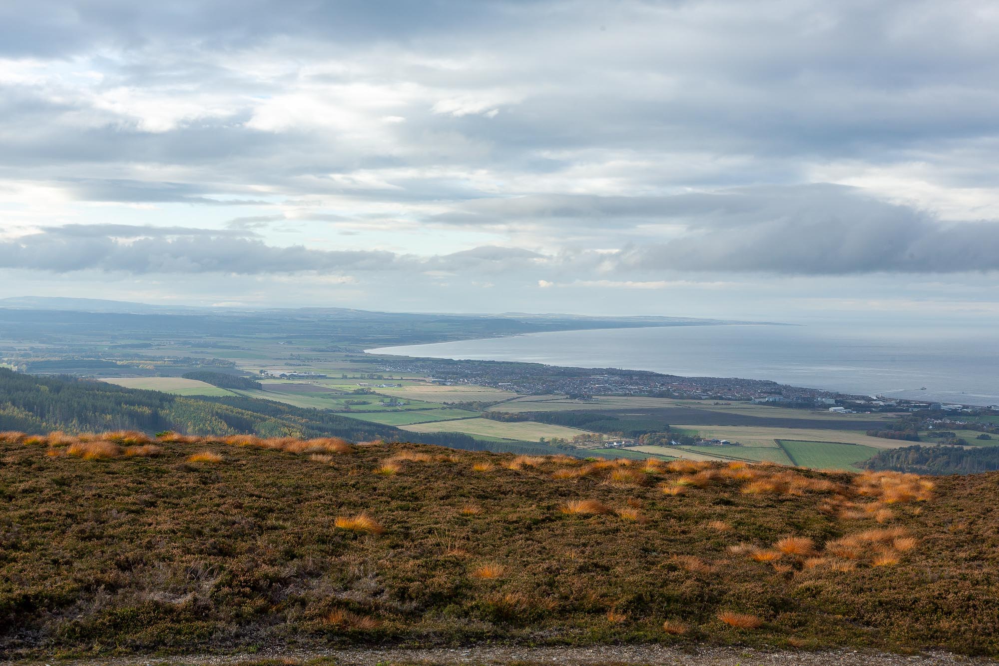
With the final push out of the way, you step onto the rounded summit and the view suddenly opens up in every direction. On our visit it was genuinely dizzying – a clean, unbroken 360-degree sweep of coast, fields, firth and distant mountains. The summit itself is covered in heather, still showing late purple tinges on our October visit.


On the summit itself you’ll find three things: a concrete Ordnance Survey trig point (the triangulation pillar used for the original OS mapping of Britain), a stone cairn, and a circular metal view indicator showing the direction of landmarks in every direction. Sadly the view indicator has been vandalised and smashed – a real shame, and if there’s a local group or benefactor out there who might help restore it, that would be a fine thing for future visitors.


There are also two solid wooden picnic benches up here, which make a fine lunch spot. The small plaques on them show they were provided by the Buckie Boys’ Brigade – a nice reminder that many of these little local features exist thanks to quiet effort from community groups.
The view from the top
The 360-degree panorama from the Bin is what makes the climb worth it, and on a clear day it is genuinely one of the finest views in the northeast. Looking north, the entire southern shore of the Moray Firth unfolds from Lossiemouth in the west to Banff and Macduff in the east, with the Caithness mountains sitting on the horizon far across the water. On a properly clear day you can pick out the Black Isle, and the pointed cone of Tarbat Ness lighthouse far across the firth.
Inland, Ben Rinnes and the Cairngorms rise to the south on clear days, with Knock Hill much closer to the southeast. Ben Wyvis, more than 100 km to the north, is sometimes visible too.
Working around the horizon, here are the main landmarks to look out for:
Buckie
The largest town visible from the summit. Buckie is directly north-northwest, and from this elevation you get the whole town laid out below you – the harbour, the various churches (Buckie has a lot of churches for its size), the supermarkets, the schools, and the long line of houses stretching from Buckpool to Portessie. It’s the town I grew up in, and seeing it like this still gives me a bit of a thrill.

Cullen
To the north, the whole town of Cullen is spread out around its bay, with the striking Victorian railway viaduct cutting right through the middle of it. Cullen House, the historic seat of the Seafield Estate, is visible too, as is the Castle Hill viewpoint on the east side of town. Cullen is also famous for giving its name to that most Scottish of soups – if you’re not familiar, my traditional Cullen Skink recipe is a good place to start.


Portknockie & Findochty
Directly north, you can see the clifftop village of Portknockie with its famous Bow Fiddle Rock just offshore, and the colourful fishing cottages of Findochty around its harbour. Both villages are well worth a visit if you’re making a day of it.
Banff & Macduff
On a clear day the twin towns of Banff and Macduff sit on the horizon to the east, and you may even catch a glimpse of Troup Head, a gannet colony and nature reserve further along the Aberdeenshire coast.

Lossiemouth
Far across the bay to the northwest, Lossiemouth is clearly visible, including its East Beach and the distant shape of Covesea Lighthouse. With binoculars you can sometimes pick out the RAF Lossiemouth airfield and the Typhoon jets coming and going.

Spey Bay
Spey Bay, where the mighty Spey – the fastest-flowing river in Scotland – empties into the Moray Firth, is visible to the west. The mouth of the Spey is a notable hotspot for dolphins, seals and, increasingly in recent years, orcas and ospreys.
Inchgower Distillery
Right beside Buckie, you can pick out the pagoda roofs and warehouses of Inchgower Distillery, one of Moray’s many working whisky distilleries. Inchgower’s whisky is a key component of the Bell’s blend. There’s a personal connection for me here: my grandfather worked at Inchgower, so I always get a lump in my throat spotting the cupolas from the summit.

Morven & the Caithness hills
Far across the Moray Firth to the north, the Caithness mountains form a distant ridge on the horizon. The distinctive conical peak of Morven (706 m) is the easiest to pick out.
Knock Hill
To the southeast, Knock Hill near Huntly (430 m) cuts an almost identical conical silhouette to the Bin itself – another quartzite hill that has stood firm while the surrounding softer rock eroded away.

Fochabers
To the southwest, on a clear day, you can pick out the village of Fochabers, home of Speyfest, one of the best traditional music festivals in Scotland.
Wildlife & nature on the Bin Hill
The Scots pine plantation on the lower slopes is classic habitat for red squirrels, crossbills and treecreepers, and if you’re very lucky (and very quiet) you might catch a glimpse of a pine marten – they’re present in the forests across this part of Moray, though they’re mostly active at dawn and dusk. Common buzzards and kestrels are often overhead, and the open heather moorland on the upper slopes is home to meadow pipits, skylarks in spring and summer, and the occasional hunting raptor.
The autumn ferns are a real highlight – acres of yellow set against the dark green of the Scots pine. The upper heather moorland bursts into purple in late August and early September, and there’s a good showing of wild flowers along the track edges in summer: harebells, foxgloves, and the occasional early-summer orchid.
A longer alternative: the Cullen House circular
If you’ve got the legs for a bigger day, there’s a longer circular route that starts from the Cullen House car park just south of Cullen. It follows the Glen Burn and the Burn of Deskford up through Shirralds Wood, summits the Bin, and returns via Little Bin, High View Plantation, Moss Hill Plantation and Foulford Bridge. It comes in at around 13 km (8 miles) with about 420 metres of ascent, taking 3 to 4 hours. The paths are mostly forestry tracks but some of the return sections through Moss Hill can be overgrown, so this is one for drier months if possible. For most visitors the straightforward out-and-back from the Hill of Maud car park is the sensible choice, but the Cullen House circular is a nice option for seasoned walkers looking for more of a day out.
Best time to visit & what to wear
The Bin can be climbed at any time of year, but autumn is genuinely spectacular – the ferns turn yellow, the Scots pine glows, and the summit heather still carries late colour. Spring and early summer bring long daylight hours, wild flowers and plenty of birdsong. Winter walks are rewarding if you time it right, and on a crisp clear winter day the long-distance views are extraordinary, but the summit is exposed and can be bitterly cold and windy, and forest tracks can be icy.
For the out-and-back route, sturdy trainers or light walking boots are fine. The track is mostly good forestry surface with one or two muddier patches, and the final stony section is loose but not technical. I’d always bring a waterproof jacket regardless of the forecast – the summit is exposed and Moray weather can flip quickly. Water and a snack are sensible for the top; there’s no source of either at the trailhead.
FAQs on the Bin of Cullen walk
How fit do you need to be to climb the Bin of Cullen?
Reasonable general fitness is enough. I’m honest about my own – I was out of breath on the last climb and my heart rate was up – but I made it. Seasoned walkers will find it a very easy outing; most reasonably active adults and older children should manage fine with breaks.
Is the walk suitable for children?
Yes. Our kids were 6, 10 and 12 on our visit, and they all managed fine with only a modest amount of grumbling about sore legs. There are no sheer drops, although the steep section near the summit does need a bit of care. Younger children may find the full distance hard without plenty of stops.
Are dogs welcome?
Yes. The Bin is a fine dog walk, but please keep dogs under close control – the surrounding forestry is actively used by deer and you may encounter forestry operations or livestock on adjoining estate land. There are no dog waste bins anywhere on the route, so you’ll need to carry waste back with you.
Can I take a pushchair or buggy?
Up to a point. An off-road or jogger-style buggy with decent wheels will cope fine with the wide forestry tracks on the lower section, but the upper rocky zig-zags and the final approach to the summit are not buggy-friendly. A child carrier backpack is a much better option for the full walk.
Are there toilets or facilities at the trailhead?
No. There are no toilets, no bins, and no water at the start of the walk. The nearest public toilets are in Cullen or Buckie.
Is there public transport to the walk?
Unfortunately not. No bus routes run directly past the car park. The Stagecoach 35 between Elgin and Aberdeen stops in Cullen, from where you’d need to either drive the final stretch or add a fairly steep 45-minute walk up the B9018 and the Hill of Maud road to reach the trailhead.
Who owns the Bin of Cullen?
The Bin and its surrounding forestry are part of the Seafield Estate, owned by the Ogilvie-Grant family, with a long historical connection to nearby Findlater Castle and Cullen House.
Is the Bin of Cullen a Munro?
No. Munros are Scottish hills over 3,000 ft (914 m). At 320 m (1,049 ft), the Bin is much more modest. It is, however, a sub-2,000 ft Marilyn, meaning it has at least 150 m of prominence – so it does make it onto hill-baggers’ lists, just not the Munro list.
Is there mobile phone signal on the walk?
Signal was patchy in the lower forest sections (I’m on the Three network), but I had full bars on the summit. Don’t rely on it for navigation lower down – download an offline map before you set off.
Is the Bin of Cullen very busy?
No, it’s a quiet walk. On our October Sunday we passed three or four small groups and had the summit to ourselves. Weekends in good summer weather are busier, but you’ll never find it crowded by Munro standards.
Key information
- Distance: 5.5 km / 3.5 miles return (out and back)
- Time: 2 to 3 hours at a gentle pace
- Ascent: Roughly 250 m
- Difficulty: Moderate – wide forestry tracks with a stony, steeper final climb
- Location: Hill of Maud road, near Deskford, between Cullen and Buckie, Moray
- Grid reference (car park): NJ491632
- What3words (car park): ///pinches.immediate.zones
- Managed by: Seafield Estate
- Entry: Free
- Parking: Small unsigned gravel area at the estate gate, space for about six cars – do not block the gate
- Facilities: None at the trailhead; two picnic benches on the summit. Nearest toilets in Cullen or Buckie
- Accessibility: Not suitable for wheelchairs. Off-road buggies fine on the lower track but not the summit approach
- Dogs: Welcome, under close control; carry waste out
Videos from the Bin of Cullen walk
Here are a few short video clips from our walk.
What else is nearby?
If you’re spending a day or two in the area, there’s plenty to combine with a climb of the Bin. Here are my top picks.
Castle Hill, Cullen
A short, easy walk right in the town of Cullen itself, with fine views over Cullen Bay and Seatown. Well worth pairing with a Bin climb if the weather holds. Read my guide to Castle Hill in Cullen.
Bow Fiddle Rock, Portknockie
A sea arch made from the same Cullen Quartzite that forms the Bin itself – one of the most photographed natural features on the Moray coast, and only a few minutes’ drive from Cullen. Read my Bow Fiddle Rock guide.
Cullen Caves and the Portknockie coastal walk
A walk along the coast from Cullen Beach to Portknockie, taking in sea caves, Jenny’s Well and the spectacular Whale’s Mouth rock arch. Read the coastal walk guide.
Findlater Castle
A dramatic ruin perched on a quartzite cliff between Cullen and Sandend – the original seat of the Ogilvies who went on to build Cullen House and still own the Seafield Estate. Read my Findlater Castle guide.
Crannoch Circular Walk
Another great walk close to Cullen, with lovely views of Cullen Bay and the Bin itself from the other direction. A good one for families. Read the Crannoch Circular guide.
Final thoughts
The Bin of Cullen had been on my “really must do” list for far too long – a hill I’d lived next to for most of my life but only stood on once, as a child. Finally climbing it properly, with Janette and the girls, turned out to be one of those simple days that exceeds expectations. The forest is beautiful, the summit view is genuinely world-class by modest-Scottish-hill standards, and the whole thing can be comfortably done in an autumn afternoon with cameras and a packed lunch.
If you’re visiting Cullen, Buckie, Portknockie or anywhere else on this stretch of the Moray coast, do make time for the Bin Hill. Pair it with the Crannoch Circular Walk or the Cullen to Portknockie coastal walk, finish with a bowl of Cullen Skink in the town, and you’ve got yourself one of the best days out in Moray. For more ideas in the area, have a look at my 5-day Moray itinerary.


Leave a comment below
Comments:
I will be dragging Ian up there before long
Chris that is brilliant thank you
I’m on the sight IM FAE BUCKIE FAR YE BIDEN NOO love seeing all the beautiful pics and stories I’ve been back visiting Buckie since I left and have done a lot of walking along the beautiful coast
Love going back to see old friends and reminiscing 🤗ðŸ‘🤩
Thanks
Amazing pictures , love the hints and tips section .
Thanks Chris
I am ashamed to admit being born in Buckie and now 60 years old, I have only climbed the bin once when I was a child and have always wanted to do it again with my grandchildren. I was unsure of the way to get to the starting point and was worried I would get lost half way up the hill.
I cannot thank you enough for sharing this information and I can now give it a go before I get too old to do it and share the experience with my granddaughters.
I am sure many folk will share my views and give it a go thanks to you Chris
Well done again
Best wishes
Jean
My mothers people came from somewhere in that area….they were Andersons.
I will never get to go there in this lifetime butI have seen drone footage of your area. Your climb up that Bin Hill was awesome. What a view.
My in-laws called it Bonnie Scotland. They said the people were the cleanest on earth. Now I know they were true. I dont know how they could leave such a beautiful place. They must have often been homesick.