Hidden away in the wild limestone landscape of Assynt, the Bone Caves at Inchnadamph are one of Scotland’s most extraordinary archaeological sites. Perched high on the cliff face of Creag nan Uamh – the “Crag of the Caves” – these four natural caverns have yielded an astonishing haul of ancient animal bones, including the remains of reindeer, brown bear, arctic fox, lynx, and even what may be Scotland’s only polar bear. Human burials dating back some 4,500 years have been found here too, making this a place where Scotland’s deep past feels tantalisingly close. The walk to reach them is a beauty in its own right, following the Allt nan Uamh burn through a rugged highland glen that feels utterly timeless.
History of the Bone Caves
The Bone Caves owe their existence to the Durness limestone that underlies this corner of Assynt. The cave system began forming over 200,000 years ago as meltwater percolated through cracks in the rock, slowly dissolving and hollowing out the limestone. Subsequent glacial action deepened the valley of the Allt nan Uamh, leaving the caves stranded high and dry on the cliff face – around 200 feet above the valley floor – where they remain today.
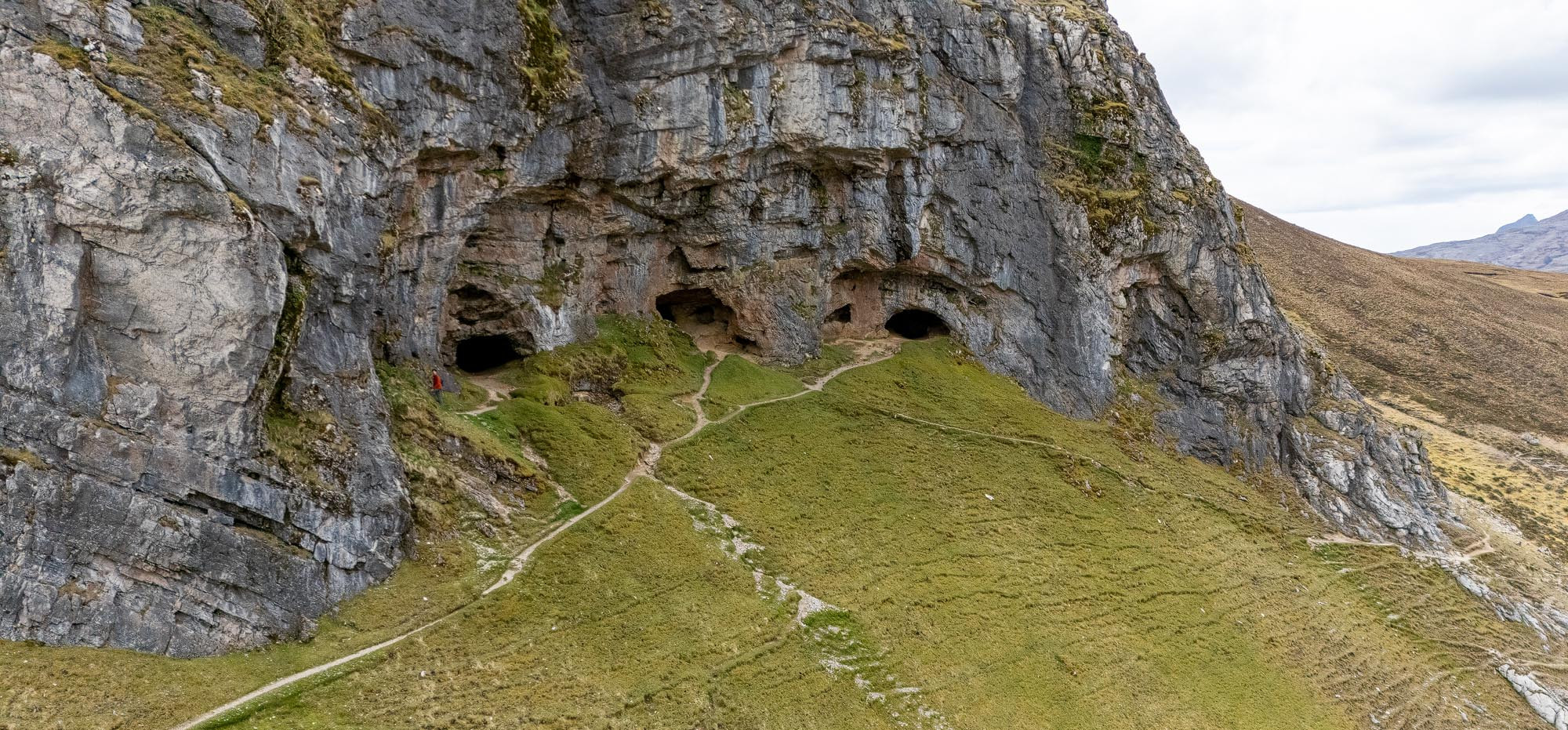
There are four caves in total, arranged in a rough horizontal line across the face of Creag nan Uamh. Each has been given its own name based on the excavation finds: Bone Cave, Reindeer Cave, Badger Cave, and Fox’s Den. The three larger caves are each around five metres deep and tall enough to stand up in, while Fox’s Den is shallower, more of a rock shelter than a true cave.

The caves first attracted serious attention in 1885 during work for the Geological Survey of the British Isles. Two prominent geologists, Ben Peach and John Horne – who had spent years mapping the complex geology of the northwest Highlands – returned to excavate in 1889. They partially dug out what is now known as Bone Cave and found fragments of bone from a range of sub-arctic species. It was an exciting start, but the absence of significant human remains meant the caves were largely forgotten for nearly four decades.
The story picks up again in 1925, when a reindeer antler and a bear’s tooth were found lying on the ground near the caves – apparently kicked up by burrowing rabbits. This lucky find caught the attention of geologist J.E. Cree, who launched proper excavations between 1926 and 1927 alongside colleagues James Ritchie and J. Graham Callander. This time the results were remarkable. The team excavated Bone Cave, Reindeer Cave, and Badger Cave, unearthing the remains of wildcat, arctic fox, frogs, land snails, and – most significantly – an intact lynx skull. This Northern lynx, dated to around 1,770 years ago, remains the only one ever found in Scotland.
Over 1,000 fragments of reindeer antler have been recovered from the caves in total, with radiocarbon dates ranging from an almost incomprehensible 47,000 years ago right through to around 8,300 years ago. The sheer quantity of antler suggests the glen below may once have served as a calving ground for reindeer herds. Other finds include the remains of brown bear and what some researchers believe to be polar bear – though this identification remains hotly debated among scholars.

Perhaps the most poignant discoveries were of human remains. In Reindeer Cave, a human skull – missing its jaw – was found within a small stone enclosure, suggesting a deliberate burial. A second set of human bones was found in a niche in the cave wall. Carbon dating placed these remains at around 4,500 years old, firmly in the Neolithic period. While there’s no evidence that people ever actually lived in the caves, these burials hint at their ritual or ceremonial significance to the communities who inhabited Assynt thousands of years ago.
Among the more unusual artefacts recovered was a walrus ivory pin, dated to around 50 AD, along with a bone awl and what appeared to be an iron blade – tantalising evidence of the caves’ continued use across multiple eras of human history.
The caves hadn’t finished revealing their secrets either. In 1995, a group of cavers exploring the deeper Uamh an Claonaite system – which lies below the Bone Caves and forms part of Scotland’s longest cave passage – discovered the skeleton of a brown bear. It took until 2008 to fully extract the remains, which were estimated to be over 11,000 years old. The bear is thought to have died while hibernating deep underground, its body later shifted by water through the cave system.
Today the Bone Caves are a Site of Special Scientific Interest (SSSI) managed by NatureScot, and they sit within the North West Highlands Geopark – Scotland’s first UNESCO-supported geopark. The finds from the various excavations are held at the National Museum of Scotland in Edinburgh. The caves themselves remain open to visitors as a free, open-access site.
Our Visit to the Bone Caves
Getting There and Parking
My wife Janette and I visited the Bone Caves after a stop at nearby Ardvreck Castle on Loch Assynt. From there, it’s a short drive south along the A837 to the dedicated car park, which sits on the east side of the road about two and a half miles south of Inchnadamph. The car park is well signposted and free to use, though it’s a fairly compact gravel area with space for around ten cars. When we arrived, it was already busy – a sign of just how popular this walk has become, particularly with NC500 travellers.


At the trailhead there’s a gate and a couple of excellent information boards. One – titled “Bears, bones and bleak lands” in both English and Gaelic – gives a brilliant overview of the caves’ history and the animals whose bones were found here. There’s also a Northwest Highlands Geopark board with a map of the wider Rock Route. It’s well worth spending a few minutes reading these before setting off, as they really set the scene for what you’re about to see.

The Walk In
The walk to the Bone Caves is around 2.5 kilometres each way and follows the Allt nan Uamh – the “Burn of the Caves” – upstream into a steadily narrowing glen. The path starts out as a clear gravel track past a small building, before climbing gently through heather and rough grassland. It’s a well-worn path and easy to follow throughout, though it is rough and uneven underfoot in places, so decent footwear is a must.

Early on, the path passes above a lovely little waterfall on the burn – a nice appetiser for what’s to come. Janette was ahead of me at this point, keen to press on, and I had to call her back so I could get a photograph of her beside it. The sound of the water tumbling over the rocks was a constant companion as we walked.

As we continued up the glen, the landscape opened out beautifully. The valley is hemmed in by sweeping hillsides of heather and rough grass, with boulders and scattered rocks lining the path. It has that wonderful sense of remoteness that the northwest Highlands do so well – even though you’re only a short walk from the road, it feels like you’re stepping into genuine wilderness.


One of the real highlights of the walk comes about halfway along, where the path passes a remarkable natural spring – the Fuaran Allt nan Uamh. Here, an underground watercourse bursts out from the base of a crag, flowing over brilliant green moss-covered limestone. The water is crystal clear and the whole scene is incredibly photogenic. The limestone geology means that the river actually flows underground through much of the upper glen, resurfacing at this point. It’s a fascinating feature and one that had us stopped for quite a while.


Beyond the spring, the valley becomes noticeably drier – the river has disappeared underground – and the views start to open up magnificently. We caught glimpses of what I believe was Ben More Assynt or Conival rising in the distance, its flanks still dusted with snow. It was a moody, overcast day when we visited, but honestly that just added to the atmosphere. This is a landscape that suits dramatic skies.

As we walked deeper into the glen, I spotted movement on the hillside above us. Three red deer were picking their way along the ridge, silhouetted against the grey sky. It was a lovely moment and a reminder that this valley is still very much alive with wildlife – just as it was thousands of years ago when reindeer, lynx, and bears roamed these same slopes.

Approaching the Caves
As we rounded a bend in the path, the limestone cliffs of Creag nan Uamh suddenly came into view ahead of us – a dramatic wall of pale grey rock rising above the valley. The cave entrances are visible from some distance, dark openings in the cliff face that draw the eye immediately. You can see why the geologists were intrigued.

The path crosses the (usually dry) river bed and then begins the steepest section of the walk – a climb up the hillside towards the base of the cliffs. Part of this ascent is on well-laid stone steps, which makes the going easier than it might otherwise be, though it’s still quite a pull. There are warning signs about rockfall danger near the cliffs, so it’s worth keeping an eye on what’s above you.


Exploring the Caves
And then you’re there, standing at the mouth of the first cave with the valley falling away beneath you and that vast cliff rising overhead. It’s a genuinely thrilling spot. The caves are arranged in a line along the cliff and you can walk between them on a narrow path that traverses the steep grassy slope – Janette found this bit a little nerve-wracking, but it’s manageable if you take your time.

We explored each of the accessible caves in turn. The larger ones are about five metres deep and tall enough to stand in comfortably, though they get dark quickly towards the back. I’d recommend bringing a torch – we had our phone lights, which did the job, but a proper torch would have been better. The floors are earthy and can be slippery, so watch your step. It’s remarkable to think that bones up to 47,000 years old were found buried in layers of sediment beneath the surface you’re walking on.

The real magic, though, is the view from inside the caves looking out. Standing in the mouth of one of the larger caves and gazing out across the glen, with the hills rolling away in every direction, is one of those moments that stays with you. You can’t help but imagine what it must have been like for the animals – and perhaps the people – who sheltered here thousands of years ago. The view hasn’t changed. The wind still blows through the valley. The same sense of shelter and safety the caves offered then, they offer now.


The Walk Back and Valley Views
After spending a good while exploring the caves and soaking in the views, we made our way back along the path that continues across the steep slope below the cliffs before descending back into the glen. This section gives you a wonderful perspective back up at the caves from below, and the views down the valley are stunning.


I also flew the drone from near the caves, which gave us an incredible aerial perspective of the whole site. From above, you can really appreciate how the four cave openings sit in a neat line across the cliff face, and the scale of the glen below is breathtaking. The drone footage captured the full sweep of the valley with the mountains beyond – it’s one of those places that looks even more impressive from the air.

The walk back follows the same route in reverse, and it’s just as enjoyable the second time. The whole circuit took us around two to two and a half hours including time exploring the caves and stopping for photographs. It’s not a long walk, but it packs in an extraordinary amount of interest for its length.

Videos from the Bone Caves, Inchnadamph
Frequently Asked Questions
How long is the walk to the Bone Caves?
The walk is approximately 5 kilometres (3 miles) round trip from the car park. Allow around 2 to 2.5 hours for the full walk including time to explore the caves. The path is generally well defined but includes a steep climb to reach the cave entrances.
Is the walk to the Bone Caves difficult?
The walk is moderate overall. The path along the glen is relatively flat and easy going, but the final section up to the caves is steep and narrow. The path between the caves traverses a steep slope. Good walking boots or sturdy footwear are recommended as the path can be rough and uneven, and cave floors are slippery.
Is the Bone Caves walk suitable for dogs?
Yes, dogs are welcome on the walk as it is open access land. However, the steep section near the caves and the narrow paths between them may be challenging for some dogs. Please keep dogs under close control, especially during lambing season (spring) and deer stalking season (autumn).
Are there any facilities at the Bone Caves?
No. There are no toilets, cafés, or shops at the car park or along the walk. The nearest facilities are at the Inchnadamph Hotel (approximately 2.5 miles north) or in Lochinver (approximately 15 miles). Bring your own water and snacks.
Can you still see bones in the caves?
No. All of the bones and artefacts discovered during the various excavations have been removed and are now held at the National Museum of Scotland in Edinburgh. The caves themselves are empty but remain atmospheric and well worth visiting for their geological interest, historical significance, and the stunning views from the cave entrances.
Do I need a torch to explore the caves?
A torch is strongly recommended. While the cave mouths are open and well lit, the interiors get dark very quickly. The caves are only around five metres deep but the rear sections are in near total darkness. A phone torch will suffice, but a proper head torch is better.
Is the walk suitable for children?
The walk along the glen is suitable for older children who are confident walkers. The steep section near the caves requires care and close supervision. It is not suitable for pushchairs or buggies. Very young children may struggle with the length of the walk and the uneven terrain.
Key Information
- Location: Creag nan Uamh, Inchnadamph, Lairg, Sutherland IV27 4HN
- Grid Reference (car park): NC 253 179
- Grid Reference (caves): NC 268 170
- Managed by: NatureScot (SSSI designation) – open access site
- Entry: Free
- Parking: Free car park on the A837, space for approximately 10 cars
- Facilities: Information board at car park only. No toilets or café
- Accessibility: Not wheelchair accessible. Steep, uneven terrain. The walk involves approximately 165 metres of elevation gain
- Dogs: Welcome, under close control
What Else is Nearby?
Ardvreck Castle – Just 2.5 miles north on Loch Assynt, the atmospheric ruins of this 15th-century MacLeod stronghold are free to visit and make a natural pairing with the Bone Caves. The castle sits on a rocky promontory jutting into the loch, with the ruins of nearby Calda House adding to the scene.
Knockan Crag National Nature Reserve – About 10 miles south near Elphin, this free NatureScot site is where the famous Moine Thrust was first identified. There’s an excellent Rock Room exhibition and a trail that lets you literally touch the point where 500-million-year-old rock sits on top of 1-billion-year-old rock.
Traligill Caves – Another impressive network of limestone caves in the neighbouring Traligill Valley, accessible from Inchnadamph. These are larger and include an impressive waterfall sink at the mouth of one cave. A good companion visit if you’re interested in the area’s geology.
Eas a’ Chual Aluinn – Britain’s highest waterfall at 200 metres, accessible by a walk from the road or by boat from Kylesku. On a wet day the falls are spectacular, plunging over a cliff edge into the glen below.
Lochinver – The main village in Assynt, about 15 miles west, is a lovely place to stop for food. The Lochinver Larder is famous for its pies, and there are several cafés and restaurants serving fresh local seafood.
Final Thoughts
The Bone Caves at Inchnadamph are one of those places that deliver on every level. The walk is beautiful, the scenery is dramatic, and the history is genuinely fascinating. Standing in a cave that once sheltered lynx, bears, and arctic foxes – and where Neolithic people chose to bury their dead – is a deeply moving experience. You won’t find any bones here now, but you will find a connection to Scotland’s deep past that’s hard to match anywhere else in the country. We visited after Ardvreck Castle, and the two made for a brilliant afternoon in Assynt. Don’t miss it.


Leave a comment below