NC500 East Coast Road Trip – Three Days From Helmsdale to the Bone Caves
The North Coast 500’s east coast section doesn’t always get the love it deserves. Most guides rush through it on the A9, treating it as the warm-up act before the dramatic west coast scenery kicks in. That’s a mistake. The stretch from Helmsdale to John o’ Groats and beyond is packed with history, atmosphere and a raw kind of beauty that’s entirely its own – and on this trip, Janette and I set out to prove it.
We’d already explored the Golspie and Dornoch area many times over the years, so this particular trip picked up from Helmsdale and headed north through Caithness to John o’ Groats, before swinging back south through the heart of Sutherland and ending up at the Bone Caves near Ullapool. Three days, two nights at the Thurso Premier Inn, and a route that took in Iron Age brochs, Highland Clearance villages, sea stacks, clifftop castles and one of the most dramatic waterfalls in Scotland. This is the east coast of the NC500 done properly.
Day 1 – Helmsdale to Thurso: Clearances, Brochs and Bronze Age Mysteries
Our first day was dominated by a theme we hadn’t planned but which quickly became inescapable: the Highland Clearances. From our very first stop at the Emigrants Statue to the ruins of Badbea and Borg Village, the echoes of displacement and hardship were everywhere along this stretch of coast.
The Emigrants Statue, Helmsdale
We started in Helmsdale, pulling into the car park just south of the bridge on the A9. From here it’s a short uphill walk to Couper Park, where the Emigrants Statue stands overlooking the village and harbour. Sculpted by Gerald Laing and unveiled in 2007, this powerful bronze depicts a family on the brink of emigration – the man gazing forward into an uncertain future, a boy looking up for reassurance, and a woman clutching an infant, her gaze cast back towards the home they’re leaving behind.

It’s a genuinely moving monument, and standing there on a spring morning with yellow gorse blazing on the hillsides, the emotional weight of it really hits home. The inscription commemorates those who “in the face of great adversity, sought freedom, hope and justice beyond these shores.” This would set the tone for much of the day ahead.
Ousdale Broch and Borg Village
Continuing north along the A9 and crossing into Caithness, we turned off to visit Ousdale Broch and Borg Village. The Caithness Broch Project have done a fantastic job here, creating a well-maintained path through the heather to the 2,000-year-old broch. About halfway along the path, you pass the ruins of Borg – a clearance village dating back to at least 1560, abandoned during the Clearances. The name derives from the Old Norse for “fort,” likely a reference to the nearby broch.

The broch itself is impressive – a substantial circular drystone structure with visible entrance passage, intramural chambers and remnants of a spiral staircase. It was quite windy when we visited, making the uphill return a bit of a slog, but worth every step. We had previously visited Carn Liath Broch near Golspie, and it’s fascinating to compare the two – Ousdale feels much more remote and exposed.
Badbea Clearance Village
A short drive further north brought us to Badbea, one of the most poignant sites on the entire NC500. This clifftop clearance village is a stark reminder of the desperation faced by families evicted from their inland homes. The ruins cling to the windswept edge of the Caithness coast – the wind is so fierce here that, according to local tradition, children and livestock had to be tethered to prevent them being blown over the cliffs.

Walking among the low stone walls with the sea crashing below and nothing but gorse and heather for company, you get a visceral sense of just how harsh life must have been here. Between the Emigrants Statue, Borg Village and Badbea, we’d encountered three different faces of the Clearances in a single morning – a powerful and humbling experience.
Dunbeath Broch
After two emotionally heavy stops, the peaceful walk to Dunbeath Broch felt like a welcome change of pace. The trail follows the lovely Dunbeath Strath Path alongside the river, through trees that arch over the path creating an almost tunnel-like effect. A slightly wobbly wooden bridge crosses the river before a stepped path climbs to the broch site itself.

This broch is quite unique in that it sits on top of a hill within a walled enclosure, surrounded by trees. It looks almost like a churchyard without the church. The conservation work carried out by the Berriedale and Dunbeath Community Council has been superb – excellent information boards explain the broch’s 2,000-year history. If you’re new to Scottish brochs, Dunbeath would be a perfect first visit.
Dunbeath Harbour
We popped down to Dunbeath Harbour afterwards – partly because it looked interesting, and partly because we needed the public toilets. I’m glad we did. This tiny harbour is a lovely spot with far more to see than you’d expect: a memorial statue to writer Neil M. Gunn, views of the private Dunbeath Castle perched on its rocky promontory, and information boards packed with local history.

Hill o’ Many Stanes
Our final stop before reaching Thurso was the wonderfully named Hill o’ Many Stanes near Lybster. This Bronze Age site consists of roughly 200 miniature standing stones set in unique fan-shaped rows – not the towering monoliths you might expect, but small slabs barely reaching thigh height, carefully placed in deliberate patterns across the hillside.

Nobody’s entirely sure what the Hill o’ Many Stanes was for. Some believe it tracked lunar or solar alignments; others think it served as a ceremonial centre. Whatever its purpose, walking among these ancient stones on a quiet Caithness hillside is a wonderfully atmospheric experience. We made Thurso by early evening and checked into the Premier Inn for the first of two nights.
Day 2 – John o’ Groats and the Caithness Coast: Signposts, Sea Stacks and Sinclair Country
Day two was all about the Caithness coastline – a loop from Thurso to John o’ Groats and back down through the villages of Nybster and Keiss, ending at the spectacular Castle Sinclair Girnigoe. This was the day with the most driving, but also the most variety.
John o’ Groats
We arrived at John o’ Groats on a gloriously sunny morning and headed straight for the famous signpost. It’s one of those things you simply have to do – 874 miles from Land’s End, 3,230 from New York, and just 6 from Orkney. Unlike Land’s End, there’s no charge to take your photo here, which feels like a nice touch.

John o’ Groats has had quite a makeover in recent years. The Inn with its colourful lodges is now a local landmark, and there are decent cafes, gift shops and even a craft distillery. We were pleasantly surprised by how much there was to see and do. Parking is £3.50 per day, with all funds going to the local development trust.
Duncansby Head and the Stacks
If we’re being honest, Duncansby Head was the real reason we’d driven this far north. Just two miles east of John o’ Groats, this headland is the true most north-easterly point of the British mainland – and the Duncansby Stacks are, without question, one of the most spectacular natural formations in Scotland.

The walk from the lighthouse car park to the stacks takes about 15 minutes along a grassy cliff path, and nothing quite prepares you for the moment they come into view. Enormous jagged pinnacles of layered Old Red Sandstone, over 60 metres tall, rising vertically from the sea. I got the drone up and the aerial perspective really shows how these stacks were once part of the mainland, gradually carved away over millennia. Don’t make the mistake of turning around at John o’ Groats – drive those extra two miles.
Nybster Broch
Heading south along the coast, we stopped at Nybster Broch – one of the most important Iron Age broch settlements in Caithness. What makes Nybster special is its dramatic clifftop promontory setting, with the broch and associated structures perched right on the edge of the coast. The curious Mervyn’s Tower, built in the 19th century from excavated broch stones, adds an unusual extra element.

Old Keiss Castle
From Nybster we continued to Keiss, where we parked at the harbour and walked the coastal path to Old Keiss Castle. This late 16th-century tower house is one of the most dramatically positioned ruins in Scotland – clinging to a crumbling sandstone cliff with the North Sea swirling below. Parts of the castle have already fallen into the waves, and it genuinely looks like it could follow at any moment.

The walk along from Keiss Harbour also passes several well-preserved WW2 Type 24 machine gun pillboxes – Sinclair’s Bay was considered highly vulnerable to invasion from Nazi-occupied Norway during the Second World War.
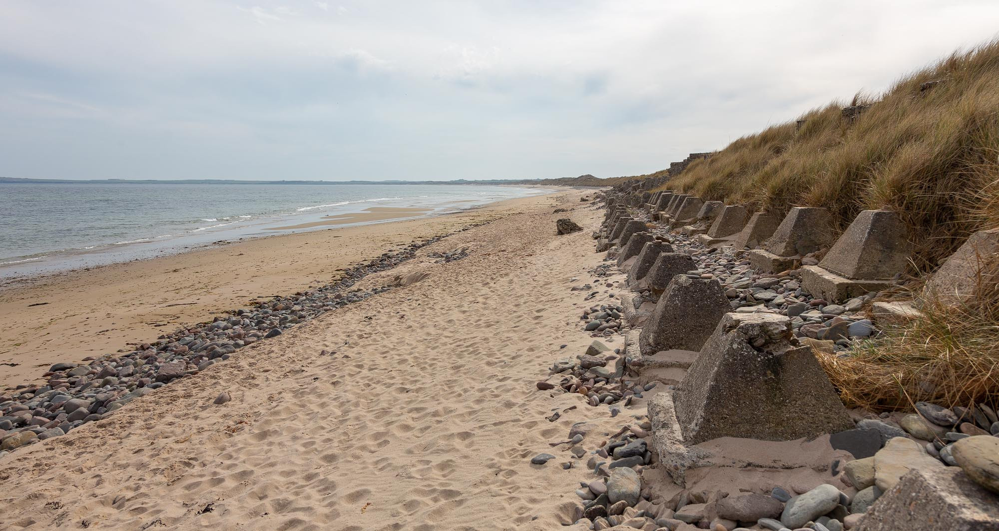
Keiss Beach
Keiss Beach itself is a beautiful stretch of sand on Sinclair’s Bay. What caught our eye were the WW2 anti-tank defences – rows of concrete “dragon’s teeth” still standing along the beach after more than 80 years, a stark reminder of the wartime threat to this remote corner of Scotland.

Castle Sinclair Girnigoe
Our final stop of the day was Castle Sinclair Girnigoe, and it was a fitting finale. This 15th-century fortress, once the seat of the Sinclair Earls of Caithness, sits on a dramatic rocky promontory just north of Wick. It’s the only Scottish castle to have been listed by the World Monuments Fund as one of the 100 most endangered sites in the world.

The history here is remarkable – and grim. The 4th Earl imprisoned his own son in the dungeons for seven years before having him fed only salted beef with nothing to drink; the boy died insane from thirst. The Clan Sinclair Trust have done impressive conservation work, including building a modern footbridge where the original drawbridge once stood. After a full day of exploring, we headed back to Thurso for our second night.
Day 3 – Lairg, Assynt and the West: From the Flow Country to the Bone Caves
Our third day took us away from the east coast entirely, cutting south through the heart of Sutherland via Lairg and then west into the dramatic landscapes of Assynt. This was a longer driving day, but the variety of scenery – from the vast peatlands of the Flow Country to the mountains and lochs of Assynt – was extraordinary.
Ferrycroft Visitor Centre, Lairg
Our first stop was the Ferrycroft Visitor Centre in Lairg, a great little facility with an excellent exhibition about the Flow Country – Europe’s largest blanket bog and a globally important carbon store. There’s a good play park outside for families, and it’s a useful place to pick up local information and stretch your legs before heading west.

Ferry Wood and Broch, Lairg
Just a short distance from the visitor centre, Ferry Wood offered a pleasant woodland walk with a bonus – the remains of another broch. The Forestry and Land Scotland site is well maintained with good paths through mixed woodland. The broch ruins are less dramatic than Ousdale or Dunbeath, but the setting is lovely, overlooking the loch with hills beyond.

Wailing Widow Falls
Heading west on the A837 and then north on the A894, we reached Wailing Widow Falls in Assynt – and this was one of the highlights of the entire trip. This 30-metre waterfall plunges from Loch na Gainmhich into a steep-sided gorge that feels genuinely otherworldly. The walk in takes about 15 minutes over rough, rocky ground, but nothing quite prepares you for the moment the falls come into full view between the towering gorge walls.

The legends attached to the place add an extra layer of atmosphere – a young hunter who fell to his death from the cliff edge, and his widowed mother who threw herself after him. Whether the stories are ancient folklore or more recent invention, they suit the dark, dramatic character of the gorge perfectly.
Ardvreck Castle, Loch Assynt
A short drive south along the A837 brought us to Ardvreck Castle on the shores of Loch Assynt. This 15th-century MacLeod stronghold stands on a rocky promontory jutting into the loch, with the mountains of Assynt providing a backdrop that’s hard to beat anywhere in Scotland.

The castle is free to visit and you can walk right up to the walls. Combined with the nearby ruins of Calda House, it’s a wonderfully atmospheric stop. We spent about half an hour here before making the short drive to our final destination.
The Bone Caves, Inchnadamph
We finished our three-day trip at the Bone Caves at Inchnadamph – and what a way to end. These limestone caves, set high in the cliffs of Creag nan Uamh, once sheltered brown bears, lynx, Arctic foxes and wolves, with bones dating back thousands of years. Neolithic human burials were also discovered here, making this one of the most significant archaeological sites in Scotland.

The walk up to the caves is steep and involves about 165 metres of elevation gain, but the reward is standing inside a cave that was occupied by some of Scotland’s most impressive predators – and by our distant ancestors. The view out from the cave mouth towards the Assynt mountains, with Janette silhouetted in the entrance, was one of the best photographs of the whole trip.

Practical Tips for This Route
If you’re planning a similar trip, here are a few things we learned along the way:
- Accommodation: We stayed at the Thurso Premier Inn for two nights, which was a solid, affordable base. Thurso is the largest town on the north coast and has supermarkets, fuel and restaurants – useful after a day in remote countryside where facilities are scarce.
- Fuel: Fill up before leaving Inverness or wherever you’re starting from. Fuel stops along the east coast are available at Helmsdale, Wick and Thurso, but once you head into Assynt on Day 3, options are very limited until Ullapool.
- Toilets: Public toilets are available at Helmsdale, Dunbeath Harbour, John o’ Groats, Wick and the Ferrycroft Visitor Centre in Lairg. Many of the more remote stops (brochs, Badbea, the Bone Caves) have no facilities at all.
- Timing: We did this trip in April, which was ideal – long enough days to fit everything in, yellow gorse everywhere, and very few other visitors at most sites. Summer would be busier, especially at John o’ Groats and Duncansby Head.
- Drone flying: Many of the best photographs on this trip were taken with my drone. Always check airspace restrictions before flying, and be mindful of wildlife – particularly nesting seabirds at Duncansby Head and Nybster during spring and summer.
Frequently Asked Questions
How long does this route take?
We did it over three days with two nights in Thurso. You could compress it into two days if pushed, but you’d lose the ability to properly explore each stop. Three days feels about right for a relaxed pace with plenty of time for walking, photography and soaking up the atmosphere.
Is this route suitable for campervans?
Most of it is fine for campervans. The A9 and A99 on the east coast are good roads, and even the A837 and A894 through Assynt, while single-track in places, are well maintained with passing places. Parking at some of the more remote stops (Ousdale Broch, Wailing Widow Falls) is limited, so arrive early in summer.
Can I do this as part of a full NC500 circuit?
Absolutely – this is essentially the anti-clockwise east coast section of the NC500, from Helmsdale to John o’ Groats, with our Day 3 cutting across to the west coast via Lairg and Assynt. You could easily connect this to the north coast and west coast sections for a full circuit.
What about the section south of Helmsdale to Inverness?
We’d already done that stretch many times, including Dunrobin Castle, Carn Liath Broch, Dornoch and the Cromarty Ferry. It’s a brilliant section in its own right and well worth the time – I’d recommend at least a full day for it.
Are the walks on this route difficult?
Most are short and manageable. The walk to Ousdale Broch is about 1km each way with a steady gradient; Dunbeath Broch is a 10–15 minute stroll; Duncansby Stacks about 15 minutes on grass. The Bone Caves walk is the most challenging – steep with 165m of elevation gain. Wailing Widow Falls involves picking over rocks and boulders. Sturdy footwear is essential for all of them.
Is this route family-friendly?
With some caveats, yes. John o’ Groats, Dunbeath Harbour and Ferrycroft Visitor Centre are all great for families. The brochs and Badbea are manageable for older children. The Bone Caves and Wailing Widow Falls are less suitable for very young children due to the rough terrain and cliff edges. Dogs are welcome at all outdoor sites but should be kept on leads near livestock and cliff edges.
What’s the best time of year for this trip?
April to June is ideal. The days are long, the gorse is in bloom, and visitor numbers are still manageable. July and August bring peak crowds, especially at John o’ Groats and Duncansby Head. September and October can be beautiful but days are shorter. Avoid the winter months unless you enjoy very short days and the possibility of road closures in Assynt.
Final Thoughts
This trip reminded us why we love exploring Scotland so much. The east coast of the NC500 isn’t the dramatic mountain-and-sea combination you get on the west, but it has something the west coast often lacks – depth of history. In three days we encountered Iron Age engineering, Bronze Age astronomy, Viking place names, the horror of the Clearances, World War Two defences, and some of the oldest geological formations in Europe. And when Day 3 delivered us into the mountains and lochs of Assynt, the landscape shifted into something equally breathtaking but in a completely different way.
If you’re planning an NC500 trip and tempted to rush the east coast, I’d urge you to reconsider. Take the time to explore these sites properly. Stop at the brochs, walk through the clearance villages, stand beside the Emigrants Statue and think about the people who once lived here. The east coast has stories to tell – you just have to be willing to listen.
All information was correct at the time of writing, please check things like entry costs and opening times before you arrive.


Leave a comment below