Nybster Broch, Caithness – An Iron Age Settlement on the Edge of the World
Perched on a windswept promontory above sheer sandstone cliffs on the Caithness coast, Nybster Broch is one of Scotland’s most spectacular Iron Age settlements. This isn’t just a single broch – it’s the remains of an entire village, with around 18 buildings clustered around a central roundhouse, all connected by passages and interlinked structures. The site has been occupied for well over a thousand years, from the Bronze Age right through to the Pictish and Norse periods, and the layers of history are written into every stone wall and grassy mound.
What makes Nybster particularly special is its accessibility and its setting. A short walk along a beautiful coastal path brings you to one of the most important archaeological sites in mainland Scotland, where you can explore freely among walls that were built over 2,000 years ago. Add in the bizarre curiosity of Mervyn’s Tower, stunning cliff scenery, and the chance to spot marine wildlife, and you’ve got a stop that deserves far more attention than it gets on the NC500 route.

The History of Nybster Broch
The story of Nybster stretches back over 3,000 years. The first construction on this dramatic headland was a defensive rampart, the earliest phase of which dates to the Middle Bronze Age. At some point between the 1st and 4th centuries AD, this enclosure was modified to create a structure similar to a blockhouse – a type of fortified entrance found at sites in Orkney and Shetland. Some archaeologists believe this blockhouse may even predate the broch itself, making the site’s history even more complex and fascinating.
The broch – or Atlantic roundhouse, as archaeologists now prefer to call it – was probably built between around 200 BC and 200 AD. It has an internal diameter of roughly 6.24 metres (about 23 feet) with walls averaging an extraordinary 4.7 metres (14 feet) thick. This gives it the largest wall-to-diameter ratio of any known Atlantic roundhouse, though the relatively small interior suggests it was more modest than some of its Caithness neighbours. Despite those enormously thick walls, no intramural features like guard chambers or mural cells have been found – unusual for a broch, but possibly a local Caithness building tradition.
What makes Nybster truly remarkable is that it wasn’t just a single building. Over time, a complex village grew up around the roundhouse, with cellular buildings, living areas with hearths and ovens, stone-lined tanks, and subsidiary cells, all connected by passages. Archaeological excavations have revealed gaming pieces hinting at leisure activities, tools for leatherworking and textile production, whetstones and anvils for iron tools, and – most excitingly – a Roman melon bead and fragments of 2nd-century Samian pottery. These exotic imports, along with evidence of non-ferrous metalworking, indicate that Nybster was a high-status settlement with connections far beyond the Caithness coast.

The site continued to be used well into the Pictish period (AD 300–800) and beyond, with evidence suggesting some structures may have been reused during the Norse period. Several stone cist-like structures were cut into the rampart rubble, containing pottery sherds, worked bone, crucible fragments, and copper alloy – possibly linked to burial practices in the later periods of the site’s use.
The first modern excavation of Nybster was carried out by the Reverend James Maxwell Joass of Golspie in 1895. Shortly afterwards, Sir Francis Tress Barry – a wealthy former MP who lived at nearby Keiss Castle – conducted more extensive excavations between 1895 and 1900. Tress Barry was a prolific (if somewhat heavy-handed by modern standards) archaeologist who excavated 14 brochs in just 14 years. His approach was more antiquarianism than archaeology as we would recognise it today, but he did uncover the remarkable extent of the settlement.
In 2004, a survey was carried out by a team including AOC Archaeology Group, the University of Nottingham, and the National Museum of Scotland. This was followed by full excavation seasons in 2005 and a community dig in 2011, which confirmed that despite Tress Barry’s earlier clearance, much of the original Iron Age and Norse period archaeology remained intact. Nybster is now recognised as a Scheduled Ancient Monument and is considered one of the most important broch sites on mainland Scotland.
Our Visit to Nybster Broch
Getting There and Arrival
Janette and I arrived at Nybster after visiting Duncansby Head earlier in the day. We were driving south along the A99 from John o’ Groats when we spotted the signpost for the broch. The turn-off is well signposted on the seaward side of the A99, about three miles north of Keiss and seven miles south of John o’ Groats, and you follow a short track down to a small gravel car park.

The car park is small – space for perhaps six to eight cars – but it’s free and there’s a dog waste bin provided. When we arrived, we were the only ones there, which was a lovely surprise for such an important archaeological site. The flat, open landscape of Caithness spread out around us, with scattered crofts and farmhouses dotting the green fields under a wide sky.
The Walk to the Broch
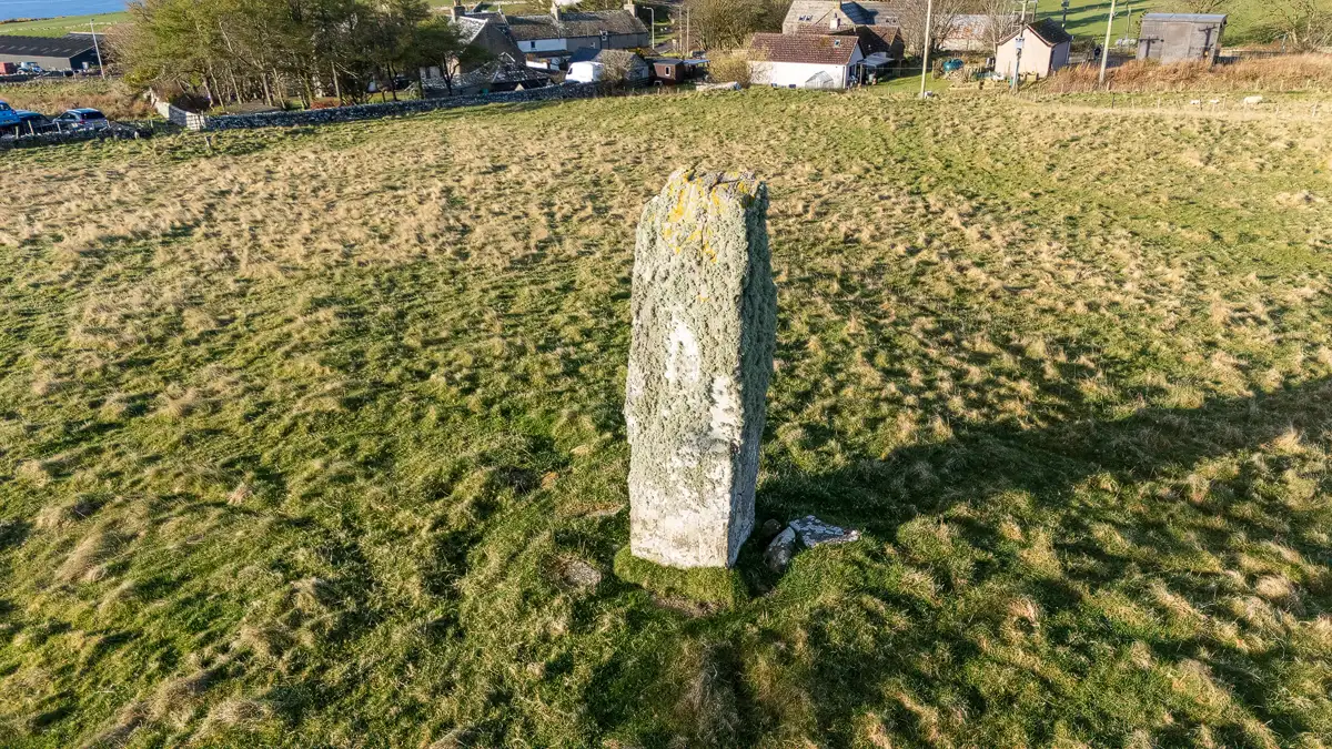
Before even setting off along the path, there are things to see right by the car park. A couple of stone monuments sit near the start of the walk – these are the work of John Nicolson, a local farmer and sculptor who assisted Tress Barry with his excavations and left his own quirky mark on the landscape with his carved stone creations. One of them features a date stone and a small carved figure on top, sitting alongside what appears to be a small stepped structure with a door. They’re an intriguing appetiser for what lies ahead.

There’s an excellent interpretation board at the start of the path that gives you a helpful overview of the site’s timeline and explains the concept of brochs as “Beacons of Belonging” – imposing structures that dominated the prehistoric landscape and served as homes to important people. It’s well worth a read before you set off.

The walk to the broch follows a well-defined grassy coastal path running alongside a fence line, with the sea to your left and farmland to your right. It’s about 450 metres – roughly a five to ten minute walk – and it’s mostly flat and easy-going, though it can get a bit muddy in places after rain. The views along the way are stunning, with the layered sandstone cliffs dropping away to the North Sea and the Caithness coastline stretching into the distance.

Along the way, you pass the old Nybster harbour on your right. This is a small inlet with a ruined stone fishing bothy, a life ring, and the remains of a landing stage that was once used for offloading herring from small fishing boats. The layered sandstone cliffs here are absolutely gorgeous, with horizontal strata clearly exposed and rock platforms extending out into the sea. It’s a spot where you might see otters, and dolphins and even orca have been spotted passing along this stretch of coast.


As you continue along the path, Mervyn’s Tower gradually comes into view ahead – a strange, stepped stone structure silhouetted against the sky. The path hugs the cliff edge (there are no barriers, so take care) before arriving at the tower and the broch settlement beyond.

Mervyn’s Tower
The first structure you reach is Mervyn’s Tower, and it’s one of the most delightfully bizarre monuments you’ll encounter anywhere in Scotland. Built by local farmer and sculptor John Nicolson, it commemorates the archaeological work of Sir Francis Tress Barry (and possibly his nephew Mervyn – hence the name). The tower was originally constructed using stones taken from the broch excavation and was built right inside the broch itself. In 1987, it was relocated to its current position to the west of the broch as part of a job creation scheme.

It’s a squat, stepped structure with a square base, adorned with carved red sandstone plaques bearing the inscriptions “Mervyn Tower” and “Sir F. Tress Barry Bart”, as well as a large carved letter ‘B’ and a coat of arms. But the real stars of the show are the wonderfully grotesque carved figures – gargoyle-like creatures perched on the corners and summit. Up close, they have a real folk art quality, weathered by over a century of Caithness wind and rain but still full of character.


It’s a peculiar juxtaposition – a Victorian folly sitting next to remains that are over 2,000 years old – but it somehow adds to the character of the place. By today’s standards, removing stones from an archaeological site to build a commemorative tower would be unthinkable, but in the context of late 19th-century antiquarianism, Tress Barry and Nicolson clearly felt they were honouring the site in their own way.
Exploring the Broch Settlement
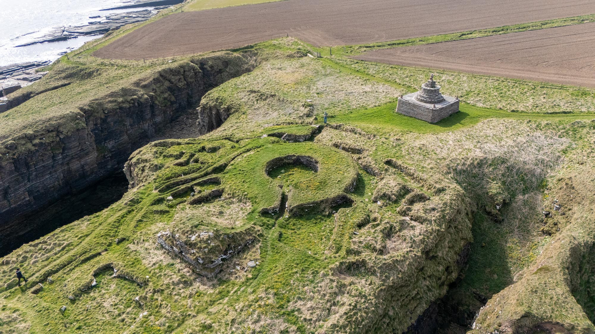
Beyond Mervyn’s Tower, the broch settlement spreads across the promontory ahead of you, and this is where Nybster really comes alive. The ruins are not behind any barrier or rope – you’re free to walk among them, peer into the outbuildings, trace the connecting passages with your feet, and get a real sense of what this community would have been like over two millennia ago.

The central roundhouse is the most prominent feature – you can clearly make out the circular wall with its impressive thickness, even though only about five feet of the walls survive. The entrance passage is still visible, and standing inside the roundhouse looking outward, you get a real sense of the structure’s defensive design. The walls may be low now, but try to imagine them towering above you as a two-storey drystone tower.

The outbuildings to the seaward side of the broch are extensive, and many are remarkably well preserved. Some are circular, some oblong, some irregular, and the connecting passages between them give the whole complex a maze-like quality. One of the larger structures has beautifully curved drystone walls, still standing several courses high, with its interior now carpeted in wildflowers. When we visited, yellow buttercups and white clover had turned several of the outbuildings into natural gardens – a lovely contrast against the grey stone and blue sea.

Janette enjoyed climbing to the top of the broch walls for a queen-of-the-castle moment, which gave a great vantage point over the whole settlement and the surrounding coastline. From up there, you can really appreciate the defensive logic of the site – steep cliffs dropping away on three sides with only the landward approach to defend, where the ditch and rampart would have provided a formidable barrier.

It’s worth taking your time here and letting the atmosphere of the place sink in. Standing among walls that were built when Rome was still a republic, looking out over the same sea that Iron Age fishermen and farmers would have watched daily, is genuinely moving. The fact that you’re likely to have the place entirely to yourself only adds to the experience.
Views from the Drone
I brought my drone along, and Nybster is a site that truly benefits from an aerial perspective. From directly above, you can see the full layout of the settlement that isn’t obvious at ground level – the circular roundhouse at the centre, the sprawling complex of outbuildings spreading across the promontory, the connecting passages, and the defensive ditch cutting across the landward approach. Mervyn’s Tower sits clearly to the west, separate from the ancient structures.

The drone footage also captured just how dramatic the coastal setting is. The cliffs here are sheer layered sandstone, dropping vertically into the North Sea, with rock platforms and stacks at their base. Looking back northward along the coast, you can see the car park, the old harbour, and the Caithness coastline stretching towards Auckengill and beyond.


Videos from Nybster Broch
Frequently Asked Questions
How much does it cost to visit Nybster Broch?
Nybster Broch is completely free to visit. It’s an open access site with no entry fee, no ticket booth, and no opening or closing times. You can visit at any time of year, day or night.
Is there parking at Nybster Broch?
Yes. There’s a small free car park signposted off the A99 on the seaward side. It can accommodate around six to eight cars. There are no parking charges, and a dog waste bin is provided.
How far is the walk to the broch?
The broch is about 450 metres from the car park, roughly a five to ten minute walk along a coastal path. The path is mostly flat and grassy but can be muddy after rain. There are no steps.
Is Nybster Broch suitable for wheelchair users?
The path is grassy and uneven, and the broch site itself involves rough terrain, so it would not be suitable for wheelchairs or those with significant mobility difficulties. The cliff edges are also unprotected.
Can I take my dog to Nybster Broch?
Yes, dogs are welcome at Nybster Broch. There’s a dog waste bin in the car park. Keep your dog on a lead near the cliff edges and be mindful of any livestock in the surrounding fields.
Are there toilets or facilities at Nybster Broch?
There are no toilet facilities at the broch or the car park. The nearest facilities are at the Caithness Broch Centre at Auckengill (seasonal opening), or at Keiss and John o’ Groats.
What is Mervyn’s Tower?
Mervyn’s Tower is a 19th-century commemorative monument built by local farmer and sculptor John Nicolson to honour the archaeological work of Sir Francis Tress Barry. It was built using stones removed from the broch excavations and features carved grotesque figures and inscribed plaques. Originally inside the broch, it was relocated to its current position in 1987.
Key Information
- Location: A99, Nybster, Caithness, Highland, KW1 4XR
- Grid Reference: ND 3702 6314
- Managed by: Historic Environment Scotland (Scheduled Ancient Monument)
- Entry: Free – open access at all times
- Parking: Small free car park signposted off the A99
- Facilities: Interpretation board at car park. No toilets. Caithness Broch Centre nearby (seasonal)
- Accessibility: Not wheelchair accessible. Uneven grassy paths and unprotected cliff edges
- Dogs: Welcome on leads. Dog waste bin in car park
- Walk: Approximately 450m (5–10 minutes) from car park
- Website: Historic Environment Scotland
What Else is Nearby?
Caithness Broch Centre, Auckengill – Just 100 metres north along the A99 from the car park turn-off, this small museum in a converted Victorian schoolhouse tells the story of the area’s brochs and displays artefacts found at Nybster. Open seasonally (April–September). Free entry.
Keiss Castle – The dramatic ruins of this 16th-century clifftop castle sit about three miles south along the coast. You can walk there from Nybster along a rough coastal path as part of the John o’ Groats Trail, though it involves some scrambling and a barbed wire fence.
Duncansby Head & Stacks – About seven miles north, this is the true northeastern tip of mainland Scotland. The walk to the Duncansby Stacks – dramatic sea stacks rising from the waves – is one of the finest short walks in Scotland.
Castle of Mey – The late Queen Mother’s beloved Scottish home sits around ten miles north on the Pentland Firth coast. The castle, gardens, and animal centre make for a wonderful half-day visit.
Castle Sinclair Girnigoe – One of Scotland’s most dramatically sited castle ruins, perched on a narrow promontory just north of Wick, about ten miles south of Nybster.
Final Thoughts
Nybster Broch was one of those stops that exceeded all expectations. We hadn’t specifically planned to visit – we spotted the sign on the way back from Duncansby Head – and ended up spending a good hour exploring the settlement, photographing Mervyn’s Tower’s gargoyles, and flying the drone above what turned out to be an incredibly photogenic site.
What struck us most was the sheer scale of the settlement. This wasn’t just a lonely tower on a clifftop – it was a thriving community where people lived, worked, played games, wove textiles, worked metal, and traded with the Roman world. The fact that you can walk freely among walls that are over 2,000 years old, with no barriers and no other visitors, is something that Caithness does better than almost anywhere else in Scotland.
If you’re driving the NC500 or visiting John o’ Groats, Nybster Broch deserves a stop. The coastal walk is beautiful, Mervyn’s Tower is a curiosity you won’t find anywhere else, and the archaeological remains give you a tangible connection to Scotland’s Iron Age past that few sites can match. Bring your walking boots, a camera, and a bit of imagination – you won’t be disappointed.

Leave a comment below