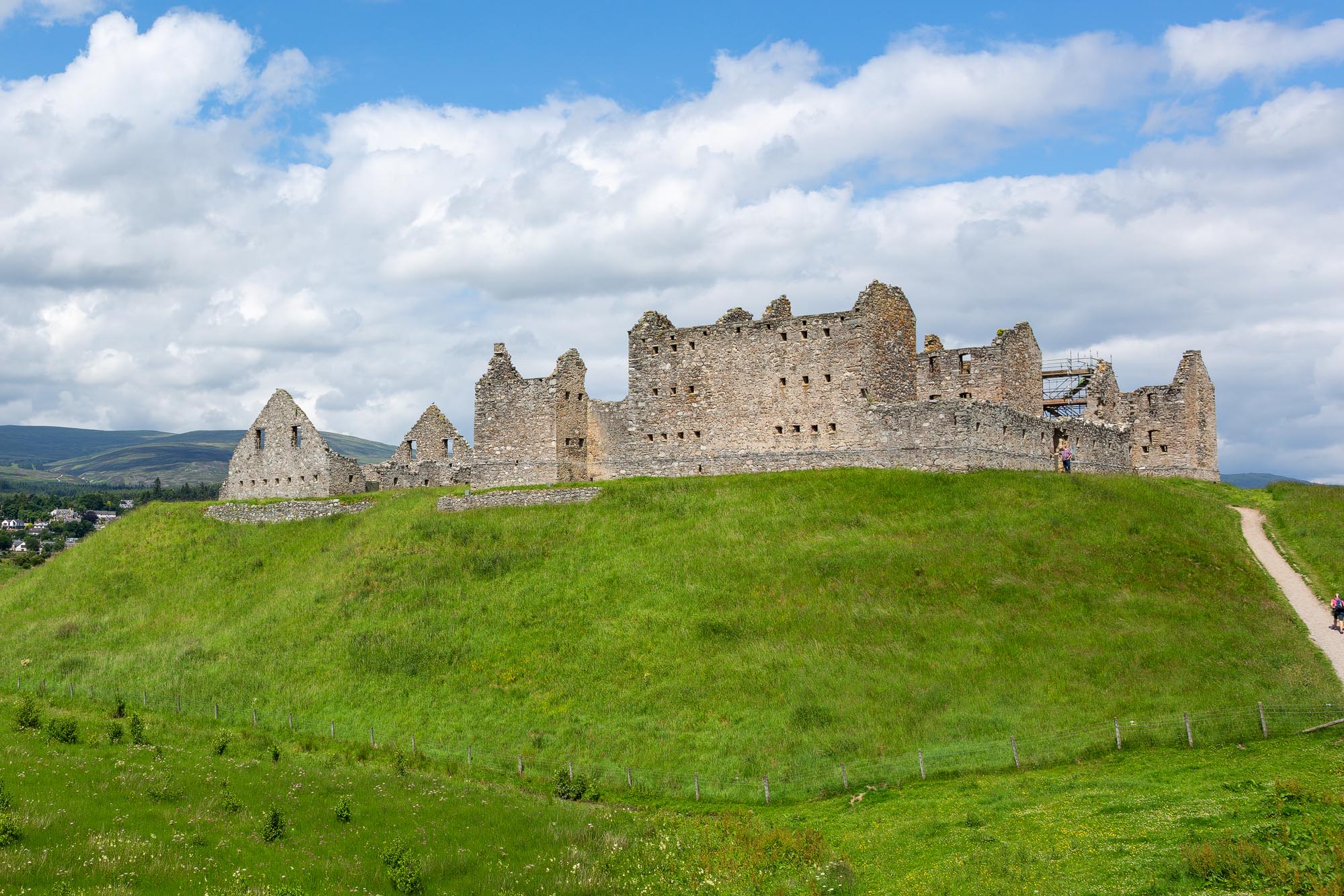
With the kids set the challenge of being first to spot the ruin – or “the castle”, as it was quickly renamed from the back seat – we approached from the east. It had been decades since I’d last stood inside those high, roofless walls, and I’d forgotten just how commanding the site is: a gaunt grey silhouette on a conical mound, visible for miles in every direction above the flat floor of Strathspey.

Ruthven Barracks is free to visit, open all year round, and ranks as one of the best-preserved Hanoverian military sites in Scotland. But the mound it stands on is far older than the barracks themselves, and the story of the fortifications on this spot stretches back the best part of eight hundred years.
The Site and Setting
About a mile and a half south-east of Kingussie, Ruthven Barracks sits atop a prominent alluvial mound of sand and gravel, likely deposited by glaciers at the end of the last ice age more than 14,000 years ago. The steep, regular sides of the mound – almost too neat to be entirely natural – suggest that human hands have helped shape it over the centuries, scarping the slopes to make them harder to climb.
The setting is extraordinary. From the top of the mound you have 360-degree views across the flat floor of Strathspey, with the River Spey winding below, the Monadhliath mountains rising to the north and the great bulk of the Cairngorms closing off the view to the east. On a clear day you can see for miles.

It’s easy to see why fortifications have stood here for the last eight hundred years. The mound overlooks the historic ford across the Spey that preceded the first bridge at Newtonmore in 1808 – one of the very few crossing points in the middle reaches of the valley – and sits on the natural route between the Monadhliath and the Cairngorms. Three of General Wade’s 18th-century military roads eventually converged nearby. The A9, the modern main route from Perth to Inverness, still follows essentially the same line.
Immediately east of the site lies Insh Marshes, an RSPB reserve that is one of the most important freshwater wetlands in Europe, home to breeding wading birds, whooper swans and occasionally otters. It’s a reminder that, before modern drainage, Ruthven would have risen out of marshland on every side – an even more formidable natural fortress than it appears today.
A Brief History of Ruthven
The Comyns and the First Castle – 1229
The first record of a castle at Ruthven dates to 1229. It was held by the powerful Comyn family, Lords of Badenoch and at that point one of the most powerful dynasties in Scotland, and became the principal seat of their lordship – a timber fortification on top of the mound controlling travel through the glen and the valuable agricultural land of Strathspey.
That power came to an abrupt end in 1306, when Robert the Bruce stabbed John Comyn, Lord of Badenoch, in front of the altar at Greyfriars Kirk in Dumfries. The killing triggered a civil war that tore Scotland apart for two years and ended with the Comyns stripped of their lands. Ruthven passed through a succession of owners before being granted to the Crown and then, in 1371, to a name that would echo through the history of the Highlands.

The Wolf of Badenoch – 1371
Alexander Stewart, 1st Earl of Buchan – a younger son of King Robert II – took possession of Ruthven in 1371. History remembers him better by his nickname: the Wolf of Badenoch. A violent and capricious man even by the standards of medieval Scotland, Alexander ran Badenoch as a personal fiefdom from his bases at Ruthven and Lochindorb, raiding his neighbours, ignoring royal authority and keeping a mistress named Mairead, much to the fury of the Church.
When Bishop Alexander Bur of Moray excommunicated him for abandoning his wife, the Wolf’s response was spectacular. In 1390 he swept down out of the Highlands with a band of Highland caterans, burned the burgh of Forres, and then descended on Elgin and put the town and Elgin Cathedral – known as the “Lantern of the North” – to the torch. The cathedral never fully recovered.
Local folklore has added a suitably diabolical epilogue. One tale holds that in July 1394 the Wolf was challenged to a game of chess by a mysterious dark stranger at Ruthven Castle. By morning every man in the castle was dead, and the Wolf himself was found lifeless in the chapel. We can safely assume he lost.
The Earls of Huntly – 1451 to 1564
In 1451 the Comyn-Stewart castle at Ruthven was destroyed by John of Islay, Earl of Ross, during one of the recurring feuds between the Lords of the Isles and the Scottish Crown. A new stone tower house was built on the site in 1459 by Alexander Gordon, 1st Earl of Huntly, in the same style as his own stronghold at Huntly Castle further east.
For the next century Ruthven belonged to the Gordons, chiefs of the powerful Clan Gordon and feudal superiors of Badenoch. Its most famous visitor came in August 1564, when Mary, Queen of Scots stayed at Ruthven during a progress through the north – one of only a handful of occasions on which a reigning Scottish monarch is recorded as having lodged here.

Siege, Civil War and Bonnie Dundee – 1594 to 1689
In 1594 the Gordon castle at Ruthven was attacked by Clan Campbell but successfully held for the Gordons by the defending Clan Mackintosh. During the Wars of the Three Kingdoms it changed hands repeatedly: taken by General David Leslie in 1647, then by Mackenzie of Pluscardine in 1649, before parliament installed a permanent garrison.
The end of the medieval castle came in 1689, at the outbreak of the first major Jacobite rising. Viscount Dundee – “Bonnie Dundee”, the dashing hero of the early Jacobite cause – laid siege to Ruthven and burned it to the ground. The stone tower was left as a roofless shell, and would stay that way for thirty years.
The New Barracks – 1719 to 1721
In the aftermath of the failed Jacobite rising of 1715, the Hanoverian government decided the time had come to tighten its grip on the Highlands. Four new fortified infantry barracks were to be built at strategic points across the north: at Ruthven, Bernera in Glenelg, Kiliwhimin (later absorbed into Fort Augustus), and Inversnaid above Loch Lomond.
The medieval ruins at Ruthven were cleared away – only the original castle well survives today – and the new barracks were constructed between 1719 and 1721. The design came from James Smith, one of Scotland’s foremost architects of the period, with construction supervised by Andrew Jelfe and the military engineer John Lambertus Romer. The finished building could house 120 soldiers in two three-storey blocks facing each other across a central parade ground, and was pierced throughout with loopholes for musket fire.
Its job, according to the orders given to its garrison, was simple: to enforce the Disarming Act of 1716 and “preserve the peace and quiet of the country” by keeping the Highland clans under control.

General Wade and the Dragoons – 1734
In 1734 a stable block was added outside the main enclosure to house 28 horses for the dragoons patrolling General George Wade’s newly built military roads. Wade’s road network – eventually some 250 miles of engineered highway, linked by handsome stone bridges such as the one at Aberfeldy – was the first major road-building project in Britain since the Romans, and its purpose was explicitly military: to allow government troops to move rapidly through the Highlands in the event of another rising.
Three of Wade’s roads eventually met near Ruthven. For a few decades the barracks sat at the heart of the government’s effort to pacify the Highlands. Then, in 1745, the plan was tested.
The ’45: Molloy’s Defence
On 29 August 1745, with Bonnie Prince Charlie newly landed on the west coast and his Jacobite army sweeping south, a force of around 300 Jacobites arrived at Ruthven to take the barracks. Inside were just twelve redcoats of the 6th Regiment of Foot, commanded by Sergeant Terence Molloy.
Against all expectation, Molloy held them off. The barracks had been designed precisely for this kind of defence, and for two days the twelve men inside poured fire through the musket loops while the Jacobites tried and failed to storm the walls. The Jacobites lost two men killed and many more wounded. Molloy lost just one man – killed, as his sergeant reported with characteristic dryness, by foolishly holding his head too high over the parapet. For his part in the defence, Molloy was promoted from sergeant straight to lieutenant.

The Siege and Surrender – February 1746
The Jacobites came back on 10 February 1746, and this time they had brought artillery. The attacking force was commanded by John Gordon of Glenbucket, and his cannon made short work of the barracks’ defences. After only a brief resistance, Lieutenant Molloy – still in command – was forced to surrender. The garrison marched out under terms, and the Jacobites now held Ruthven.
After Culloden – April 1746
Ruthven’s final moment on the stage of history came a few weeks later. On 16 April 1746 the Jacobite army was shattered by Cumberland’s redcoats at the Battle of Culloden. Somewhere between 1,500 and 3,000 survivors retreated to Ruthven under Lord George Murray, intending to regroup and fight on.
They waited at Ruthven for word from the Prince. It came on 20 April, and it was not what they were hoping for. Charles’s message read, in effect, “let every man seek his own safety in the best way he can”. The rising was over. As the men melted away into the glens, the departing Jacobites set fire to the barracks behind them, denying the Hanoverian government the use of their own stronghold.
Bonnie Prince Charlie escaped via the Hebrides to France and never returned to Scotland. The barracks were never rebuilt. What you see at Ruthven today is essentially what the Jacobites left on the morning of 17 April 1746.
The Barracks Layout and Architecture
Ruthven is unusually complete for a fortification of its age, and walking around it gives a very clear sense of how an early 18th-century garrison barracks actually worked.
The main enclosure is a rectangular walled courtyard, with a central parade ground flanked by two three-storey barrack blocks. Each block could house sixty men in six rooms, ten soldiers to a room and two to a bed. Cooking and heating were done on fireplaces in each room, with food and powder stored in the lofts and basements. The outer walls of the blocks and the enclosing curtain wall are pierced throughout with loopholes for musket fire, and bastion towers project from diagonally opposite corners to allow enfilade fire along the outer faces – a textbook arrangement of the period.
Officers had private quarters in the corner towers, alongside a guardroom, a bakehouse and a brewhouse. The garrison brewed its own beer and baked its own bread, and the men could buy alcohol on site at fixed prices: beer at 6 pence a gallon, whisky at 1 pence a gill, rum at 3 pence a half-pint, porter at 2 pence a bottle.

The ruin today is a shell – none of the internal timberwork survives – but the beam sockets are still clearly visible in the interior walls, marking the levels where the wooden floors and ceilings once divided each block into three storeys. You can also still see the old castle well, the one feature of the earlier medieval fortifications that was kept when the barracks was built around it.
Outside the main walled enclosure, to the west, lie the foundations and lower walls of the 1734 stable block. This housed the 28 horses of the dragoons who patrolled Wade’s roads, with a hayloft above the stalls and a guardroom and granary attached.
Our Visit to Ruthven Barracks
Getting to Ruthven is refreshingly straightforward. From the A9 at Kingussie, a short stretch of the B970 leads south across the Spey and within a minute or two you’re pulling into the free car park at the foot of the mound. The car park is a decent size and has room for a few coaches as well as cars, although on the morning we arrived it was nearly empty.

The path up the mound is steep, grassy and unsurfaced for the most part, and it would be a struggle with a wheelchair or a large buggy. It’s a short climb though – no more than five or ten minutes – and the view at the top is the first real reward. You emerge onto the flat terrace on which the barracks stands, with the Spey winding below and the Cairngorms filling the eastern horizon.
The ruin itself is completely open. You can walk in through the main gate, cross the parade ground, and explore both barrack blocks, the corner towers and the stable block outside the wall. Historic Environment Scotland has placed interpretation boards around the site – a dozen or so in total – which tell the story of each part of the complex. There was some conservation work underway on the east wall when we visited, a nice reminder that this is still a cared-for monument rather than a forgotten pile of stones.

I spent most of my time wandering through the two barrack blocks trying to picture what life would have been like for the redcoats stationed here: ten men to a room, two to a bed, cooking over an open fireplace, a thousand miles from the London or York barracks most of them would have come from, surrounded by a population that at best tolerated them and at worst wanted them dead. Even on a mild day it must have felt bleak. In a Highland winter it would have been a posting nobody wanted.
We spent around an hour on site in the end, and could easily have spent longer. Allow at least 45 minutes to an hour to do the place justice, longer if the weather is good and you want to sit and soak up the view.
Photographing Ruthven Barracks
Ruthven is one of the most photogenic ruins in Scotland, and I’ve come away with better photographs from here than from many better-known castles. A few things worth bearing in mind if you’re bringing a camera:
- The best light is early morning or late afternoon, when the low sun picks out the texture of the stonework and casts long shadows across the parade ground.
- The silhouette shot from the car park – with the barracks dark against a bright sky – is a classic and almost impossible to mess up.
- From inside the parade ground, shooting out through the main gate frames the Cairngorms beautifully.
- Ruthven is a superb drone subject, although you’ll want to check the latest Historic Environment Scotland rules before you fly. The mound and its isolated position give you a completely uncluttered aerial view.
- In the hour before sunset, the west face of the eastern block glows orange – worth waiting for if you have the time.

Frequently Asked Questions
How is Ruthven Barracks pronounced?
Ruthven is pronounced “Riven” – the “th” is silent, as it is in a number of old Scottish place-names. This catches plenty of visitors out.
How much does it cost to visit Ruthven Barracks?
Entry is completely free, and the site is managed by Historic Environment Scotland. If you enjoy your visit and want to support the care of Scotland’s historic monuments, you can make a donation via the Historic Environment Scotland website.
What are the opening times at Ruthven Barracks?
The barracks is an open-access site, accessible at any reasonable daylight hour, all year round. There are no gates or ticket offices. HES occasionally closes the site for conservation work or during severe weather – the HES site page will flag any closures.
Can I bring my dog to Ruthven Barracks?
Yes, well-behaved dogs on leads are welcome. There are sometimes Highland cattle grazing around the base of the mound, so keep your dog close and on a short lead.
Is Ruthven Barracks accessible for wheelchairs or buggies?
Unfortunately not. The path from the car park up to the barracks is steep, grassy and unsurfaced in parts, and there are uneven thresholds and steps inside the ruin. Visitors with limited mobility can still enjoy excellent views of the site from the car park below.
How long should I spend at Ruthven Barracks?
Allow at least 45 minutes to an hour. Keen photographers or history enthusiasts could easily spend two hours here on a good day, especially if you read all the interpretation boards.
How do I get to Ruthven Barracks?
Ruthven Barracks is just off the B970, about a mile and a half south-east of Kingussie and easily reached from the A9. You can see it on our main Live Breathe Scotland activity map. The nearest railway station is Kingussie, with regular trains on the Highland Main Line between Perth and Inverness.

Key Information
- Location: Near Kingussie, Badenoch, Highlands, PH21 1NR
- OS Grid Reference: NN 76450 99761
- Managed by: Historic Environment Scotland
- Entry: Free
- Parking: Free car park at the foot of the mound
- Facilities: None on site – interpretation boards only. Nearest toilets and cafes are in Kingussie.
- Accessibility: Steep unsurfaced path up the mound. Not suitable for wheelchairs or buggies.
- Dogs: Welcome on leads

What Else is Nearby?
Ruthven is well placed for a full day out in Badenoch and Strathspey. A few places worth combining it with:
- Highland Folk Museum – about five miles south at Newtonmore, a free open-air museum with reconstructed Highland buildings from the 1700s to the 1950s. Easily a full day on its own.
- Highland Wildlife Park – eight miles north at Kincraig, run by the Royal Zoological Society of Scotland. Polar bears, wildcats, wolves and a drive-through reserve.
- Insh Marshes RSPB Reserve – immediately east of the barracks, with trails and hides looking out over the floodplain. Best in spring for breeding waders or winter for whooper swans.
- Kingussie – the handsome Victorian village a mile to the north-west, with good cafes, a high street of independent shops and a railway station on the main Highland line. Well worth a stop for lunch or a coffee after visiting the barracks.
If you’re building a wider itinerary, have a look at my guide to the best things to do in Aviemore or my 5-day Aviemore travel itinerary, both of which include Ruthven on a loop through the area. For somewhere to stay, take a look at the Aviemore and Badenoch accommodation page.

Conclusion
Ruthven Barracks isn’t the biggest Jacobite site in Scotland, and it doesn’t have the visitor-centre polish of Culloden. What it has is atmosphere. Free to visit, usually quiet, perched on a mound that has been fortified for eight centuries, it’s one of those Highland sites where history feels genuinely close to the surface. Stand in the parade ground on a still morning, look out through the gate towards the Cairngorms, and it isn’t hard to imagine Lord George Murray’s exhausted Jacobites trudging in here in April 1746, waiting for the message that would end their dream.
If you’re driving the A9 between Perth and Inverness, or staying anywhere in the Scottish Highlands, Ruthven deserves a stop. Janette and I left agreeing it had been the best impromptu detour of the week.

Leave a comment below
Comments: